Cortz
Showing rules updates and reviews across all places.
Total edits: 25
Reviews: 3
Joined: Jun 1, 2026
Reputation: 68
Showing 1–25 of 28 activity items.
Page 1 of 2.
Mapped shape change
Old outline is gray. New outline is blue.
Jun 2, 2026 9:57 PM
Rules update
• Initial rule details submitted from the map.
Place:
Alexandersflugvöllur
Changed fields
Mapped shape change
Click to load this change into the shared map viewer here.
Before shape notes
—
After shape notes
- No-Fly Zone
| Field | Before | After |
|---|---|---|
| Flight status | Unknown | NoFly |
| Summary | — | UAVs are strictly prohibited from flying over or within 2 km of an airport due to the risk of aerial collision. The airspace of Alexandersflugvollur Airport (Saudarkrokur, Iceland) is closed to both professional and recreational flyers. This is for both safety and security reasons. |
| Mapped shapes | — | 1301f6f3-6d4a-491c-9a42-c41e3f1b8f4c |
Before
After
UAV's are strictly prohibited from flying over or within 2 km of an airport due to the risk of aerial collision. The airspace of Alexandersflugvollur Airport (Saudarkrokur, Iceland) is closed to both professional and recreational flyers. This is for both safety and security reasons.
Show inline change markers
+ UAV's are strictly prohibited from flying over or within 2 km of an airport due to the risk of aerial collision. The airspace of Alexandersflugvollur Airport (Saudarkrokur, Iceland) is closed to both professional and recreational flyers. This is for both safety and security reasons.
Jun 2, 2026 9:51 PM
Rules update
• Area of caution expanded
Place:
Ólafsfjörður
Changed fields
Mapped shape change
Click to load this change into the shared map viewer here.
Before shape notes
- Fly with caution
After shape notes
- Fly with caution
| Field | Before | After |
|---|---|---|
| Mapped shapes | fbf5ebb0-f6b1-43e0-8e5c-47afe512bacb | 5a93d657-706c-46d9-91aa-04fbbcb6ebdb |
Jun 2, 2026 9:51 PM
Rules update
• Initial rule details submitted from the map.
Place:
Ólafsfjörður
Changed fields
Mapped shape change
Click to load this change into the shared map viewer here.
Before shape notes
—
After shape notes
- Fly with caution
| Field | Before | After |
|---|---|---|
| Flight status | Unknown | Caution |
| Summary | — | There is a heliport in this area, meaning helicopters are coming in and out of the area constantly. Be cautious and/or avoid flying here to prevent mid-air collisions. |
| Mapped shapes | — | fbf5ebb0-f6b1-43e0-8e5c-47afe512bacb |
Before
After
There is a heliport in this area, meaning helicopters are coming in and out of the area constantly. Be cautious and/or avoid flying here to prevent mid-air collisions.
Show inline change markers
+ There is a heliport in this area, meaning helicopters are coming in and out of the area constantly. Be cautious and/or avoid flying here to prevent mid-air collisions.
Jun 2, 2026 9:46 PM
Rules update
• Initial rule details submitted from the map.
Changed fields
Mapped shape change
Click to load this change into the shared map viewer here.
Before shape notes
—
After shape notes
- No-Fly Zone
| Field | Before | After |
|---|---|---|
| Flight status | Unknown | NoFly |
| Summary | — | Akureyri Airport is an international airport and is a no fly zone. Stay at least 2 km away from area. |
| Mapped shapes | — | 550f4d10-52ed-44aa-a383-946067a517aa |
Before
After
UAV's are strictly prohibited from flying over or within 2 km of an airport due to the risk of aerial collision. The airspace of Akureyri International Airport (Akureyri, Iceland) is closed to both professional and recreational flyers. This is for both safety and security reasons.
Show inline change markers
+ UAV's are strictly prohibited from flying over or within 2 km of an airport due to the risk of aerial collision. The airspace of Akureyri International Airport (Akureyri, Iceland) is closed to both professional and recreational flyers. This is for both safety and security reasons.
+
Jun 2, 2026 9:39 PM
Rules update
• Rule outline/details submitted from the map for an existing rules page.
Place:
Hverfjall
Changed fields
Mapped shape change
Click to load this change into the shared map viewer here.
Before shape notes
—
After shape notes
- Fly with caution
| Field | Before | After |
|---|---|---|
| Restriction type | Air | Ground |
| Flight status | Unknown | Allowed |
| Summary | — | Hverfjall is a dormant volcanic crater south of Reykjahlio. Flying here is legal/permitted. Flying can be risky due to rough terrain, weather, and wildlife (birds). |
| Mapped shapes | — | 6726b899-fe88-4ccb-9f95-ffb44f2d6a73 |
Before
After
Hverfjall is a dormant volcanic crater southeast of the town of Reykjahlio, Iceland. The volcano is dormant of safe to visit.
Flying a drone here is not subject to a permit.

When flying in Hverfjall, you must abide by the standard Icelandic UAV regulations  ##Requirements :
- Stay under 120 meters (394 feet)
- Never fly directly over crowds
- Register as a drone pilot here: https://www.flydrone.is/register
- Keep drone in visual line of sight

Flying a drone here can be RISKY! Because of awkward terrain, weather, and wildlife (birds), flying over and around the crater can be dangerous. So if you wish to fly here, take caution, plan ahead, watch the weather, and know your drones limitations.
Show inline change markers
+ Hverfjall is a dormant volcanic crater southeast of the town of Reykjahlio, Iceland. The volcano is dormant of safe to visit.
+ Flying a drone here is not subject to a permit.
+
+ When flying in Hverfjall, you must abide by the standard Icelandic UAV regulations  ##Requirements :
+ - Stay under 120 meters (394 feet)
+ - Never fly directly over crowds
+ - Register as a drone pilot here: https://www.flydrone.is/register
+ - Keep drone in visual line of sight
+
+ Flying a drone here can be RISKY! Because of awkward terrain, weather, and wildlife (birds), flying over and around the crater can be dangerous. So if you wish to fly here, take caution, plan ahead, watch the weather, and know your drones limitations.
Jun 2, 2026 8:30 AM
Rules update
• Initial rule details submitted from the map.
Place:
Mývatn Airport
Changed fields
Mapped shape change
Click to load this change into the shared map viewer here.
Before shape notes
—
After shape notes
- No-Fly Zone / No Launch Zone
| Field | Before | After |
|---|---|---|
| Flight status | Unknown | NoFly |
| Summary | — | Myvatn Airport is a regional airstrip north of Reykjahlio. Flight there is not usually permitted. If you wish to film or photogroah here, get permission from town officials first. Other than that, stay at least 2 km away from airstrip. |
| Mapped shapes | — | 9dc97bb2-35a2-4142-a993-3f7f7aadfb2f |
Before
After
UAVs are strictly prohibited from flying over or within 2 km of an airport due to the risk of aerial collision. The airspace of Myvatn Airport (Reykjahlio, Iceland) is closed to both professional and recreational flyers. This is for both safety and security reasons.

It is a regional airstrip with little air traffic, so if you wish to fly, get permission from town officials first. Other than that, stay at least 2 km away from airstrip.

Basic Iceland UAV rules:
- Stay under 120 meters (394 feet)
- Never fly directly over crowds
- Register as a drone pilot here: https://www.flydrone.is/register
- Keep drone in visual line of sight
*this applies if permitted to fly*
Show inline change markers
+ UAVs are strictly prohibited from flying over or within 2 km of an airport due to the risk of aerial collision. The airspace of Myvatn Airport (Reykjahlio, Iceland) is closed to both professional and recreational flyers. This is for both safety and security reasons.
+
+ It is a regional airstrip with little air traffic, so if you wish to fly, get permission from town officials first. Other than that, stay at least 2 km away from airstrip.
+
+ Basic Iceland UAV rules:
+ - Stay under 120 meters (394 feet)
+ - Never fly directly over crowds
+ - Register as a drone pilot here: https://www.flydrone.is/register
+ - Keep drone in visual line of sight
+ *this applies if permitted to fly*
+
Jun 2, 2026 8:17 AM
Rules update
• Initial rule details submitted from the map.
Place:
Goðafoss Waterfall
Changed fields
Mapped shape change
Click to load this change into the shared map viewer here.
Before shape notes
—
After shape notes
- No launching or flying zone / Commercial permit required
| Field | Before | After |
|---|---|---|
| Flight status | Unknown | Permission |
| Summary | — | Drone flights over and near Goðafoss Waterfall are not allowed. Commercial permission is required to fly here. |
| Mapped shapes | — | beea2d22-984d-4572-a3d9-d5bb6379c97d |
Before
After
This waterfall near Fossholl is strictly protected by the Environment Agency of Iceland. Permits used to be issued, but those were discontinued. Commercial permission may be given for a price of 52.600 ISK (400 USD).

Basic Iceland UAV rules:
- Stay under 120 meters (394 feet)
- Never fly directly over crowds
- Register as a drone pilot here: https://www.flydrone.is/register
- Keep drone in visual line of sight
Show inline change markers
+ This waterfall near Fossholl is strictly protected by the Environment Agency of Iceland. Permits used to be issued, but those were discontinued. Commercial permission may be given for a price of 52.600 ISK (400 USD).
+
+ Basic Iceland UAV rules:
+ - Stay under 120 meters (394 feet)
+ - Never fly directly over crowds
+ - Register as a drone pilot here: https://www.flydrone.is/register
+ - Keep drone in visual line of sight
+
Jun 2, 2026 7:10 AM
Rules update
• Initial rule details submitted from the map.
Place:
Husavik Airport
Changed fields
Mapped shape change
Click to load this change into the shared map viewer here.
| Field | Before | After |
|---|---|---|
| Flight status | Unknown | NoFly |
| Summary | — | Husavik Airport is an airport southwest of Husavik, a small town on the northern coast of Iceland. To fly here, get permission from local authorities. If not, stay 2 km away from the airport. |
| Mapped shapes | — | 12f38213-3281-459d-ab7b-db85f8144e7f |
Before
After
UAVs are strictly prohibited from flying over or within 2 km of an airport due to the risk of aerial collision. The airspace of Husavik Airport (Husavik, Iceland) is closed to both professional and recreational flyers. This is for both safety and security reasons.

If you wish to fly here, check with local authorities or officials to get permission.
Show inline change markers
+ UAVs are strictly prohibited from flying over or within 2 km of an airport due to the risk of aerial collision. The airspace of Husavik Airport (Husavik, Iceland) is closed to both professional and recreational flyers. This is for both safety and security reasons.
+
+ If you wish to fly here, check with local authorities or officials to get permission.
Jun 2, 2026 7:06 AM
Rules update
• Initial rule details submitted from the map.
Place:
Kópasker
Changed fields
Mapped shape change
Click to load this change into the shared map viewer here.
Before shape notes
—
After shape notes
- No-Fly Zone
| Field | Before | After |
|---|---|---|
| Flight status | Unknown | NoFly |
| Summary | — | This area has a small airport that has low air traffic. Still it is an airport and therefore needs permission to fly. Besides that, stay at least 2 km away from airport to help prevent aerial collisions. |
| Mapped shapes | — | 8b82f6e2-75b0-4f67-a6eb-e5338c7a9649 |
Before
After
UAVs are strictly prohibited from flying over or within 2 km of an airport due to the risk of aerial collision. The airspace of Kospasker Airport (Kopasker, Iceland) is closed to both professional and recreational flyers. This is for both safety and security reasons.

Permission may be granted if you ask town officials.
Show inline change markers
+ UAVs are strictly prohibited from flying over or within 2 km of an airport due to the risk of aerial collision. The airspace of Kospasker Airport (Kopasker, Iceland) is closed to both professional and recreational flyers. This is for both safety and security reasons.
+
+ Permission may be granted if you ask town officials.
Jun 2, 2026 6:59 AM
Rules update
• Initial rule details submitted from the map.
Place:
Raufarhafnarflugvöllur
Changed fields
Mapped shape change
Click to load this change into the shared map viewer here.
Before shape notes
—
After shape notes
- No-Fly Zone
| Field | Before | After |
|---|---|---|
| Flight status | Unknown | NoFly |
| Summary | — | Raufarhafnarflugvöllur is a regional airport south of Raufarhofn, which means air traffic may be light. Permission is still required to fly here. Otherwise, stay 2 km away from the airport. |
| Mapped shapes | — | d72e2831-c550-4795-aa70-ed406774e500 |
Before
After
UAVs are strictly prohibited from flying over or within 2 km of an airport due to the risk of aerial collision. The airspace of Raufarhafnarflugvöllur (Raufarhofn, Iceland) is closed to both professional and recreational flyers. This is for both safety and security reasons.

Raufarhafnarflugvöllur is a regional airport, which means air traffic may be light. Permission is still required to fly here.
Show inline change markers
+ UAVs are strictly prohibited from flying over or within 2 km of an airport due to the risk of aerial collision. The airspace of Raufarhafnarflugvöllur (Raufarhofn, Iceland) is closed to both professional and recreational flyers. This is for both safety and security reasons.
+
+ Raufarhafnarflugvöllur is a regional airport, which means air traffic may be light. Permission is still required to fly here.
Jun 2, 2026 6:53 AM
Rules update
• Initial rule details submitted from the map.
Place:
Þórshöfn Airport
Changed fields
Mapped shape change
Click to load this change into the shared map viewer here.
| Field | Before | After |
|---|---|---|
| Flight status | Unknown | NoFly |
| Summary | — | This airport is a small, regional airport which means it has little to no air-traffic. Check with officials before flying. Otherwise, stay at least 2 km from the airport. |
| Mapped shapes | — | 519c94ac-e0f5-47bb-a253-3ae43baf44ab |
Before
After
UAV's are strictly prohibited from flying over or within 2 km of an airport due to the risk of aerial collision. The airspace of Þórshöfn Airport (Þórshöfn, Iceland) is closed to both professional and recreational flyers. This is for both safety and security reasons.

This airport is a small, regional airport which means it has little to no air-traffic. Still check with town officials before flying.
Show inline change markers
+ UAV's are strictly prohibited from flying over or within 2 km of an airport due to the risk of aerial collision. The airspace of Þórshöfn Airport (Þórshöfn, Iceland) is closed to both professional and recreational flyers. This is for both safety and security reasons.
+
+ This airport is a small, regional airport which means it has little to no air-traffic. Still check with town officials before flying.
+
Jun 2, 2026 6:49 AM
Rules update
• Initial rule details submitted from the map.
Place:
Vopnafjörður
Changed fields
Mapped shape change
Click to load this change into the shared map viewer here.
| Field | Before | After |
|---|---|---|
| Flight status | Unknown | NoFly |
| Summary | — | This area is a No-Fly Zone. Airports are generally restricted areas for flying, so check with town officials before flying. Stay 2 km away from airport. |
| Mapped shapes | — | 0b1ed528-6390-41eb-b406-8b6147f0ad01 |
Before
After
UAVs are strictly prohibited from flying over or within 2 km of an airport due to the risk of aerial collision. The airspace of Vopnafjörður Airport (Vopnafjörður, Iceland) is closed to both professional and recreational flyers. This is for both safety and security reasons.

This is a small regional airport, which means permission to fly here may be granted by the town and its officials.
Show inline change markers
+ UAVs are strictly prohibited from flying over or within 2 km of an airport due to the risk of aerial collision. The airspace of Vopnafjörður Airport (Vopnafjörður, Iceland) is closed to both professional and recreational flyers. This is for both safety and security reasons.
+
+ This is a small regional airport, which means permission to fly here may be granted by the town and its officials.
Jun 2, 2026 6:43 AM
Rules update
• Initial rule details submitted from the map.
Place:
Djúpivogur Airport
Changed fields
Mapped shape change
Click to load this change into the shared map viewer here.
| Field | Before | After |
|---|---|---|
| Flight status | Unknown | NoFly |
| Summary | — | This area is generally a No-Fly Zone controlled by the air traffic controller. Stay at least 2 km away from airport unless granted permission. |
| Mapped shapes | — | e1ee196a-9aac-42ce-b82f-72cd17b2d943 |
Before
After
UAV's are strictly prohibited from flying over or within 2 km of an airport due to the risk of aerial collision. The airspace of Djupivogur Airport (Djupivogur, Iceland) is closed to both professional and recreational flyers. This is for both safety and security reasons.

It is a small, not commonly used airport, so permission may be granted if you ask the town.
Show inline change markers
+ UAV's are strictly prohibited from flying over or within 2 km of an airport due to the risk of aerial collision. The airspace of Djupivogur Airport (Djupivogur, Iceland) is closed to both professional and recreational flyers. This is for both safety and security reasons.
+
+ It is a small, not commonly used airport, so permission may be granted if you ask the town.
Jun 2, 2026 6:32 AM
Rules update
• Initial rule details submitted from the map.
Changed fields
Mapped shape change
Click to load this change into the shared map viewer here.
Before shape notes
—
After shape notes
- No-Fly Zone
| Field | Before | After |
|---|---|---|
| Flight status | Unknown | NoFly |
| Summary | — | Flying is prohibited over and near busy airports to prevent aerial collisions. |
| Mapped shapes | — | 9cb0cb7f-f963-4730-84b3-f88d92a6a13c |
Before
After
UAV's are strictly prohibited from flying over or within 2 km of an airport due to the risk of aerial collision. The airspace of Reykjavik Domestic Airport (Reykjavik, Iceland) is closed to both professional and recreational flyers. This is for both safety and security reasons.

Permission may be granted if you ask the city to record there.
Show inline change markers
+ UAV's are strictly prohibited from flying over or within 2 km of an airport due to the risk of aerial collision. The airspace of Reykjavik Domestic Airport (Reykjavik, Iceland) is closed to both professional and recreational flyers. This is for both safety and security reasons.
+
+ Permission may be granted if you ask the city to record there.
Jun 2, 2026 6:26 AM
Rules update
• Initial rule details submitted from the map.
Changed fields
Mapped shape change
Click to load this change into the shared map viewer here.
Before shape notes
—
After shape notes
- No-Fly Zone
| Field | Before | After |
|---|---|---|
| Flight status | Unknown | NoFly |
| Summary | — | UAVs are strictly prohibited from flying over or within 2 km of an airport due to the risk of aerial collision. This airspace is closed to both professional and recreational flyers. |
| Mapped shapes | — | 41dd3ae2-68ae-46f8-8df4-dfa92afce5fa |
Before
After
UAVs are strictly prohibited from flying over or within 2 km of an airport due to the risk of aerial collision. The airspace of Keflavík International Airport (Keflavík, Iceland) is closed to both professional and recreational flyers. This is for both safety and security reasons.
Show inline change markers
+ UAVs are strictly prohibited from flying over or within 2 km of an airport due to the risk of aerial collision. The airspace of Keflavík International Airport (Keflavík, Iceland) is closed to both professional and recreational flyers. This is for both safety and security reasons.
Jun 2, 2026 6:21 AM
Rules update
• Initial rule details submitted from the map.
Place:
Hringvegur
Changed fields
Mapped shape change
Click to load this change into the shared map viewer here.
Before shape notes
—
After shape notes
- Fly with Caution. Harsh weather/terrain
| Field | Before | After |
|---|---|---|
| Flight status | Unknown | Caution |
| Summary | — | Fly with Caution here because the weather can change quickly and the wind is unpredictable. |
| Mapped shapes | — | fd75e6c5-9b92-49f9-b367-6e192ce5e5e1 |
Before
After
This area has harsh weather and terrain, making it a big risk of crashing a drone. If you choose to fly in this area, be mindful about the weather and keep your distance from the cliff faces.

Basic Iceland UAV rules:
- Stay under 120 meters (394 feet)
- Never fly directly over crowds
- Register as a drone pilot here: https://www.flydrone.is/register
- Keep drone in visual line of sight
Show inline change markers
+ This area has harsh weather and terrain, making it a big risk of crashing a drone. If you choose to fly in this area, be mindful about the weather and keep your distance from the cliff faces.
+
+ Basic Iceland UAV rules:
+ - Stay under 120 meters (394 feet)
+ - Never fly directly over crowds
+ - Register as a drone pilot here: https://www.flydrone.is/register
+ - Keep drone in visual line of sight
Jun 2, 2026 6:08 AM
Rules update
• Initial rule details submitted from the map.
Place:
Nesjahverfi
Changed fields
Mapped shape change
Click to load this change into the shared map viewer here.
Before shape notes
—
After shape notes
- No-Fly Zone
| Field | Before | After |
|---|---|---|
| Flight status | Unknown | NoFly |
| Summary | — | UAVs are strictly prohibited from flying over or within 2 km of an airport due to the risk of aerial collision. This airspace is closed to both professional and recreational flyers. |
| Mapped shapes | — | c48affe7-77f2-41e6-8327-9d8dbecf1cd2 |
Before
After
UAVs are strictly prohibited from flying over or within 2 km of an airport due to the risk of aerial collision. This airspace is closed to both professional and recreational flyers.
Show inline change markers
+ UAVs are strictly prohibited from flying over or within 2 km of an airport due to the risk of aerial collision. This airspace is closed to both professional and recreational flyers.
Jun 2, 2026 6:00 AM
Rules update
• Initial rule details submitted from the map.
Place:
Stokksnes
Changed fields
Mapped shape change
Click to load this change into the shared map viewer here.
Before shape notes
—
After shape notes
- Fly with Caution
| Field | Before | After |
|---|---|---|
| Flight status | Unknown | Caution |
| Summary | — | It is very windy here. The wind can be strong, so make sure your drone can handle the wind speed you may encounter. Check weather ahead of time. |
| Mapped shapes | — | bc29fbea-ca9f-4c0f-87e1-76adb70c84d8 |
Before
After
This area is very cold and windy, even in the summer. The exposed coast brings in a lot of cold air from the ocean, so pack warm, check the weather, and know the capabilities of your drone before visiting. Flying is more common here, so watch for other pilots and communicate with them if possible to avoid any collisions.

Basic Iceland UAV rules:
- Stay under 120 meters (394 feet)
- Never fly directly over crowds
- Register as a drone pilot here: https://www.flydrone.is/register
- Keep drone in visual line of sight
Show inline change markers
+ This area is very cold and windy, even in the summer. The exposed coast brings in a lot of cold air from the ocean, so pack warm, check the weather, and know the capabilities of your drone before visiting. Flying is more common here, so watch for other pilots and communicate with them if possible to avoid any collisions.
+
+ Basic Iceland UAV rules:
+ - Stay under 120 meters (394 feet)
+ - Never fly directly over crowds
+ - Register as a drone pilot here: https://www.flydrone.is/register
+ - Keep drone in visual line of sight
Jun 2, 2026 5:46 AM
Review
Place:
Seydisfjordur
5 out of 5 stars
5/5
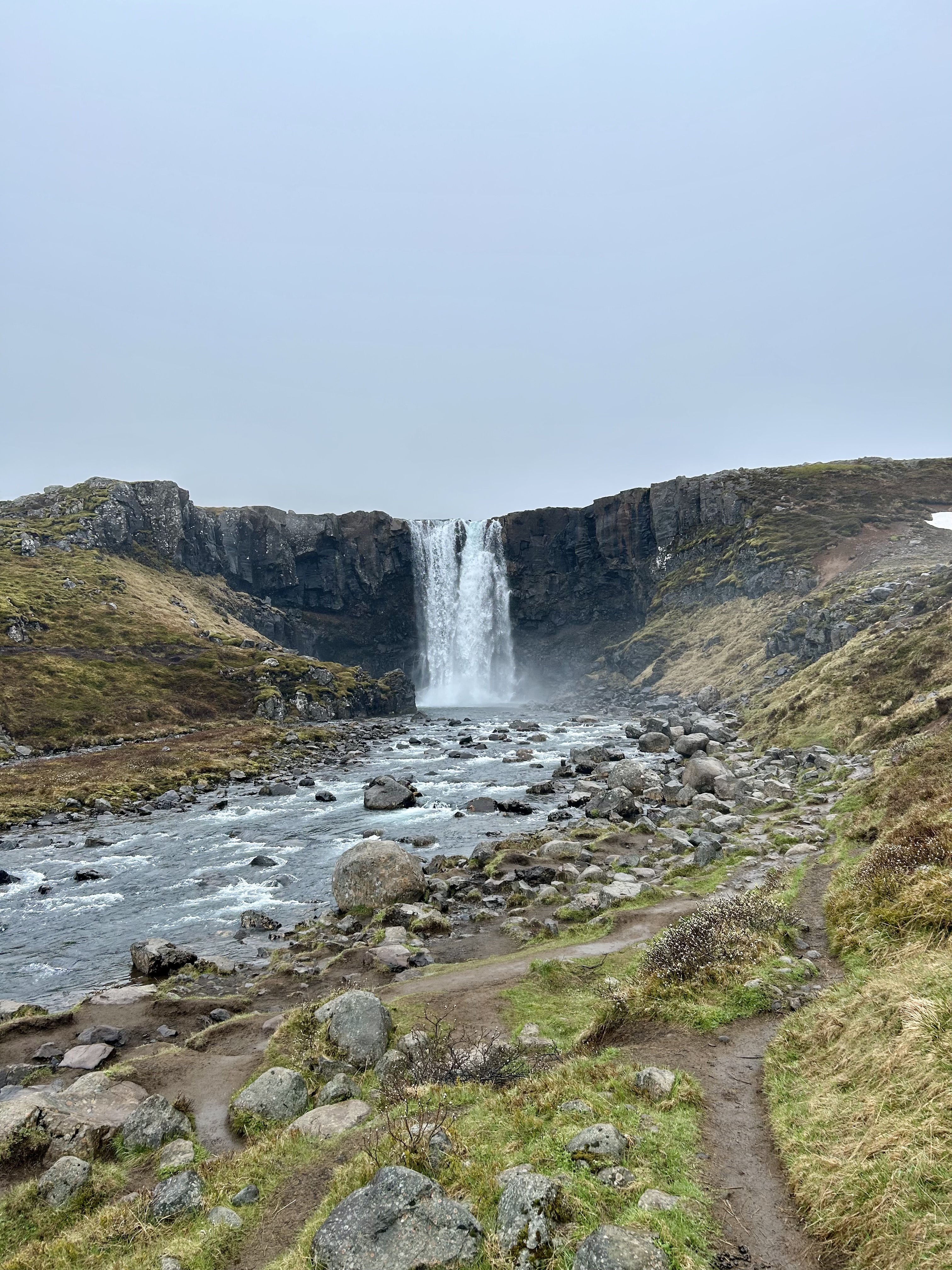
This is a beautiful waterfall near Seydisfjordur that isn't very popular for the average tourist. It is a bit out of the way; however, if you want a more surreal Iceland experience, this waterfall is a great place to visit and photograph.
Jun 2, 2026 5:35 AM
Rules update
• Initial rule details submitted from the map.
Place:
Bakkagerði
Changed fields
Mapped shape change
Click to load this change into the shared map viewer here.
Before shape notes
—
After shape notes
- No-Fly Zone
| Field | Before | After |
|---|---|---|
| Flight status | Unknown | NoFly |
| Summary | — | Restricted airspace reserved for manned aerial vehicles (planes and helicopters). |
| Mapped shapes | — | 83c1c913-36ff-4805-8498-fc43ac060322 |
Before
After
UAVs are strictly prohibited from flying over or within 2 km of an airport due to the risk of aerial collision. This airspace is closed to both professional and recreational flyers. Keep photography of the land and town out at the harbor.
Show inline change markers
+ UAVs are strictly prohibited from flying over or within 2 km of an airport due to the risk of aerial collision. This airspace is closed to both professional and recreational flyers. Keep photography of the land and town out at the harbor.
Jun 2, 2026 5:28 AM
Rules update
• Initial rule details submitted from the map.
Place:
Hafnarhólmavegur
Changed fields
Mapped shape change
Click to load this change into the shared map viewer here.
Before shape notes
—
After shape notes
- Permission Required to Fly
| Field | Before | After |
|---|---|---|
| Flight status | Unknown | Caution |
| Summary | — | Flying is permitted here any time of the year besides April 15 - July 15. |
| Mapped shapes | — | a9a771a9-4c38-4703-8975-967146d84fe5 |
Before
After
Flying near this shore line and cliffs are risky because of the nesting puffins and harsh wind. No flights are allowed during nesting season, so check with workers if you're looking to fly here.

If you fly here, you must abide by the Iceland UAV restrictions:
- Stay under 120 meters (394 feet) above ground level
- Keep a safe horizontal distance of 50 meters between the drone and any crowds, boats, or viewing platforms.
- Make sure drone is in line of sight from you or a spotter
Show inline change markers
+ Flying near this shore line and cliffs are risky because of the nesting puffins and harsh wind. No flights are allowed during nesting season, so check with workers if you're looking to fly here.
+
+ If you fly here, you must abide by the Iceland UAV restrictions:
+ - Stay under 120 meters (394 feet) above ground level
+ - Keep a safe horizontal distance of 50 meters between the drone and any crowds, boats, or viewing platforms.
+ - Make sure drone is in line of sight from you or a spotter
Jun 2, 2026 5:13 AM
Rules update
• Initial rule details submitted from the map.
Place:
Bear Stage
Changed fields
Mapped shape change
Click to load this change into the shared map viewer here.
| Field | Before | After |
|---|---|---|
| Flight status | Unknown | NoFly |
| Summary | — | No Fly Zone. Access will never be granted for recreational use. |
| Mapped shapes | — | d18e69a0-962f-422b-b3ea-a949baa6daaf |
Before
After
The Minnesota Renaissance Festival strictly prohibits the use of UAVs all year. The festival is also a popular, crowded area when open, so flying overhead goes against FAA regulation
Show inline change markers
+ The Minnesota Renaissance Festival strictly prohibits the use of UAVs all year. The festival is also a popular, crowded area when open, so flying overhead goes against FAA regulation
Jun 1, 2026 11:22 PM
Rules update
• Initial rule details submitted from the map.
Place:
Egilsstaðir Airport
Changed fields
Mapped shape change
Click to load this change into the shared map viewer here.
| Field | Before | After |
|---|---|---|
| Flight status | Unknown | Permission |
| Summary | — | No-Fly Zone |
| Mapped shapes | — | c8b3efd3-da5b-43c0-b052-c5b6c9c5843d |
Before
After
This is a no fly zone as it is near and above an airport, which is internationally prohibited without permission. This means that no flights can be taken in the town of Egilsstaðir without permission from the control tower unless on the south or eastern end.
Show inline change markers
+ This is a no fly zone as it is near and above an airport, which is internationally prohibited without permission. This means that no flights can be taken in the town of Egilsstaðir without permission from the control tower unless on the south or eastern end.
+
+
Jun 1, 2026 11:14 PM
Review
Place:
The Geothermal Exhibition
5 out of 5 stars
5/5
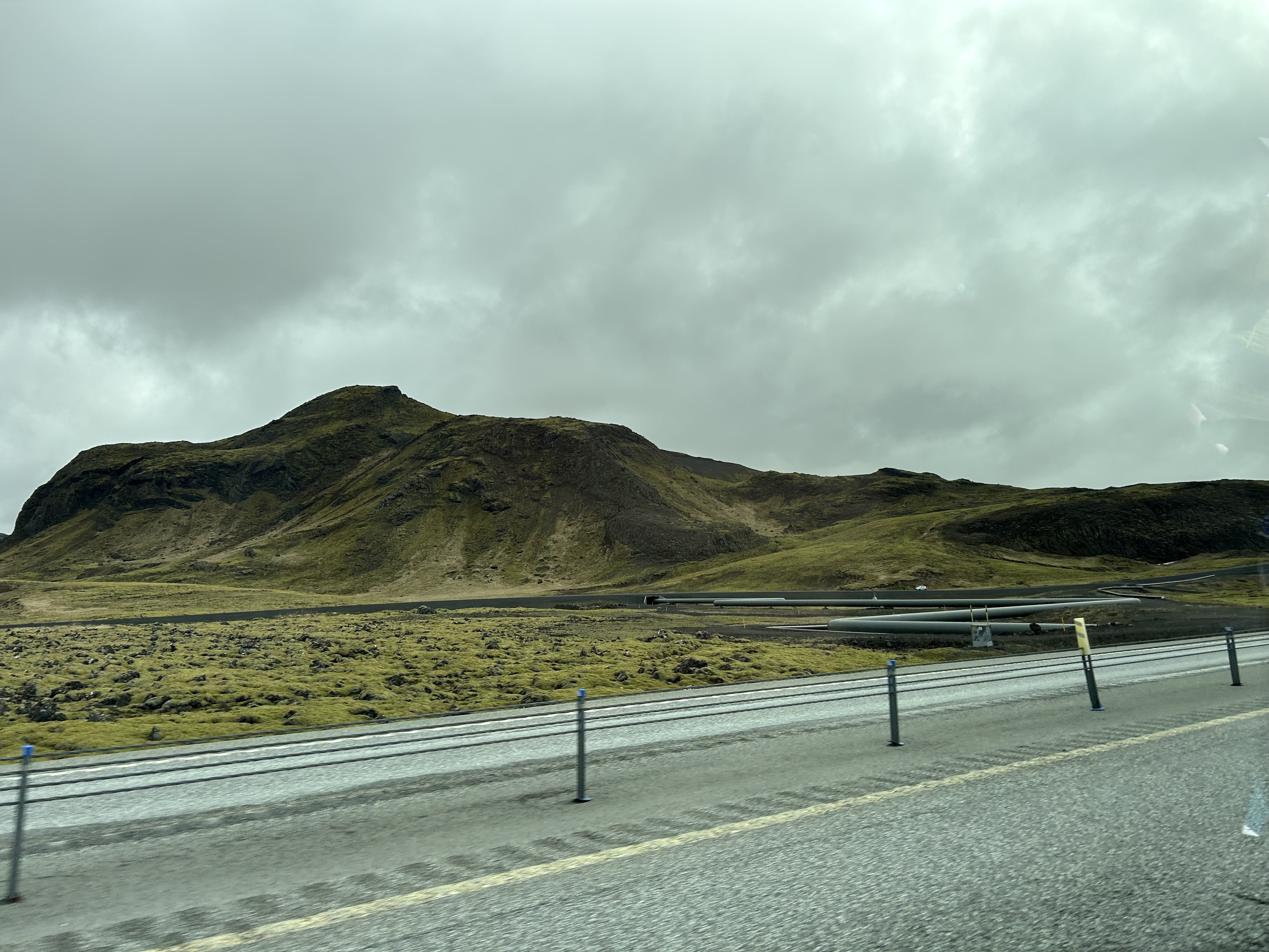
This is a cool rock formation off of Route 1, roughly ten miles east of Rykjavik. The small mountain is the backdrop of the Iceland Geothermal Exhibitition. While photographing the mountains are okay, you may need to stay off the the property of the exhibit without permission.
Jun 1, 2026 10:53 PM
Rules update
• Initial rule details submitted from the map.
Place:
781 Höfn
Changed fields
Mapped shape change
Click to load this change into the shared map viewer here.
Before shape notes
—
After shape notes
- No-Fly Zone (April 15 - June 15). Open rest of year
| Field | Before | After |
|---|---|---|
| Flight status | Unknown | Caution |
| Summary | — | Open all year besides April 15 - June 15 (bird nesting season) |
| Mapped shapes | — | 44c09bea-7057-4e9b-9b6e-ca6052aad199 |
Before
After
This area is open all year to drone flyers and is a great place to get footage and photos of the giant icebergs. However, between April 15th and June 15th, drone flying is entirely restricted to protect bird nesting.

Since this area is part of Vatnajökull National Park, if you fly, you must abide by their flight policies (linked in sources).
Show inline change markers
+ This area is open all year to drone flyers and is a great place to get footage and photos of the giant icebergs. However, between April 15th and June 15th, drone flying is entirely restricted to protect bird nesting.
+
+ Since this area is part of Vatnajökull National Park, if you fly, you must abide by their flight policies (linked in sources).