5d104498-9b8a-46f9-a233-92ea3441f332
Showing rules updates and reviews across all places.
Total edits: 13
Reviews: 1
Joined: May 28, 2026
Reputation: 32
Showing 1–14 of 14 activity items.
Page 1 of 1.
Mapped shape change
Old outline is gray. New outline is blue.
May 30, 2026 2:38 PM
Rules update
• Added rules and regulations for the Milford State Park
Place:
Milford State Park
Changed fields
Mapped shape change
Click to load this change into the shared map viewer here.
| Field | Before | After |
|---|---|---|
| Flight status | Unknown | NoFly |
| Summary | — | Drone operations within Milford State Park and adjacent KDWP-managed wildlife areas are prohibited by the Kansas Department of Wildlife and Parks (KDWP). |
| Mapped shapes | — | f29e00b5-722f-495b-a130-e382fa8c40be |
Before
After
The Kansas Department of Wildlife and Parks prohibits the operation of unmanned aircraft systems (UAS), including drones, on property it owns or manages. This restriction applies to Milford State Park as well as nearby KDWP-managed wildlife areas. Pilots who launch, land, or operate a drone from these properties may be subject to enforcement action, including a Class C misdemeanor under Kansas regulations.

While the FAA retains authority over navigable airspace, and a drone launched from a legal location outside park boundaries may technically be able to transit over portions of Milford Lake, operating near the park or wildlife areas is strongly discouraged. Launching or landing anywhere on KDWP-managed land remains prohibited regardless of the flight path.
Show inline change markers
+ The Kansas Department of Wildlife and Parks prohibits the operation of unmanned aircraft systems (UAS), including drones, on property it owns or manages. This restriction applies to Milford State Park as well as nearby KDWP-managed wildlife areas. Pilots who launch, land, or operate a drone from these properties may be subject to enforcement action, including a Class C misdemeanor under Kansas regulations.
+
+ While the FAA retains authority over navigable airspace, and a drone launched from a legal location outside park boundaries may technically be able to transit over portions of Milford Lake, operating near the park or wildlife areas is strongly discouraged. Launching or landing anywhere on KDWP-managed land remains prohibited regardless of the flight path.
May 30, 2026 2:23 PM
Rules update
• Added park boundaries and rule list, corrected names
Place:
Wilson State Park
Changed fields
Mapped shape change
Click to load this change into the shared map viewer here.
| Field | Before | After |
|---|---|---|
| Flight status | Unknown | NoFly |
| Summary | — | Drone Operations in Wilson State Parks and the surrounding wildlife areas are prohibited by the KDWP. |
| Mapped shapes | — | cc36c970-04f5-4f92-92d0-aaa2d5d3a03c |
Before
After
Drone Operations in Wilson State Park and the surrounding wildlife areas are prohibited by the KDWP. Operating in these areas can result in a Class C misdemeanor. Technically, a pilot may fly over the area, but it's still highly inadvisable, and launching or landing in any KDWP land is still illegal.
Show inline change markers
+ Drone Operations in Wilson State Park and the surrounding wildlife areas are prohibited by the KDWP. Operating in these areas can result in a Class C misdemeanor. Technically, a pilot may fly over the area, but it's still highly inadvisable, and launching or landing in any KDWP land is still illegal.
May 29, 2026 5:23 AM
Rules update
• Added mapped park boundaries and rules
Place:
Neosho Wildlife Area
Changed fields
Mapped shape change
Click to load this change into the shared map viewer here.
| Field | Before | After |
|---|---|---|
| Flight status | Unknown | NoFly |
| Summary | — | All drone operations within the Neosho Wildlife Area are strictly prohibited. |
| Mapped shapes | — | 82cc8003-ecec-4a1b-899a-cfe2cd507a9e |
Before
After
As with all land managed by the Kansas Department of Wildlife and Parks, no drone operations are allowed within the Neosho Wildlife Area for the safety and stability of the environment and wildlife.
Show inline change markers
+ As with all land managed by the Kansas Department of Wildlife and Parks, no drone operations are allowed within the Neosho Wildlife Area for the safety and stability of the environment and wildlife.
May 29, 2026 4:56 AM
Rules update
• Added mapped park boundary and rules
Changed fields
Mapped shape change
Click to load this change into the shared map viewer here.
| Field | Before | After |
|---|---|---|
| Flight status | Unknown | NoFly |
| Summary | — | All drone operations within the Jamestown Wildlife Area are strictly prohibited. |
| Mapped shapes | — | dc14b04a-33f7-49e4-bd5a-0ffa967257a9 |
Before
After
As with all land managed by the Kansas Department of Wildlife and Parks, no drone operations are allowed within the Jamestown Wildlife Area for the safety and stability of the environment and wildlife.
Show inline change markers
+ As with all land managed by the Kansas Department of Wildlife and Parks, no drone operations are allowed within the Jamestown Wildlife Area for the safety and stability of the environment and wildlife.
May 29, 2026 4:50 AM
Rules update
• Added park boundary and rules
Changed fields
Mapped shape change
Click to load this change into the shared map viewer here.
| Field | Before | After |
|---|---|---|
| Flight status | Unknown | NoFly |
| Summary | — | All drone operations within the Marais des Cygnes National Wildlife Refuge are strictly prohibited. |
| Mapped shapes | — | 832d3dad-727c-41fc-82b0-67bc13fa5a81 |
Before
After
As with all land managed by the Kansas Department of Wildlife and Parks, no drone operations are allowed within the Marais des Cygnes National Wildlife Refuge for the safety and stability of the environment and wildlife.
Show inline change markers
+ As with all land managed by the Kansas Department of Wildlife and Parks, no drone operations are allowed within the Marais des Cygnes National Wildlife Refuge for the safety and stability of the environment and wildlife.
May 29, 2026 4:39 AM
Rules update
• Added park boundary and rules.
Changed fields
| Field | Before | After |
|---|---|---|
| Summary | — | All drone operations within the Cheyenne Bottoms Wildlife Area are strictly prohibited. |
Before
After
## All drone operations within the Cheyenne Bottoms Wildlife Area are strictly prohibited.

As with all land managed by the Kansas Department of Wildlife and Parks, no drone operations are allowed within the Cheyenne Bottoms Wildlife Area for the safety and stability of the environment and wildlife.
Show inline change markers
+ ## All drone operations within the Cheyenne Bottoms Wildlife Area are strictly prohibited.
+
+ As with all land managed by the Kansas Department of Wildlife and Parks, no drone operations are allowed within the Cheyenne Bottoms Wildlife Area for the safety and stability of the environment and wildlife.
May 28, 2026 6:43 PM
Rules update
• Added rules for the Quivira National Wildlife Refuge.
Changed fields
Mapped shape change
Click to load this change into the shared map viewer here.
| Field | Before | After |
|---|---|---|
| Flight status | Unknown | NoFly |
| Summary | — | All drone operations within the Quivira National Wildlife Refuge are strictly prohibited. |
| Mapped shapes | — | 258f37c2-9560-447b-844a-8a7a123e816d |
Before
After
## All drone operations within the Quivira National Wildlife Refuge are strictly prohibited per Secretarial Directive 3379
Show inline change markers
+ ## All drone operations within the Quivira National Wildlife Refuge are strictly prohibited per Secretarial Directive 3379
+
+
May 28, 2026 6:05 PM
Rules update
• Added the Wesley Medical Center Heliport, with cautions to nearby pilots.
Changed fields
Mapped shape change
Click to load this change into the shared map viewer here.
Before shape notes
—
After shape notes
- LAANC up to 100ft
| Field | Before | After |
|---|---|---|
| Restriction type | Ground | Air |
| Flight status | Unknown | Allowed |
| Summary | — | Pilots in this area should be mindful of emergency traffic to and from the helipad. |
| Mapped shapes | e946ebe4-d277-49a5-b5ef-6cbc62790688 | 7460e9cc-8df8-4013-8bab-0b13cb8ad5eb |
Before
After
## Pilots in this area should be mindful of emergency traffic to and from the helipad.

While there are no FAA restrictions other than the nearby airport restricting LAANC to 100ft, pilots should be aware of potential traffic from the Wesley helipad.
Show inline change markers
+ ## Pilots in this area should be mindful of emergency traffic to and from the helipad.
+
+ While there are no FAA restrictions other than the nearby airport restricting LAANC to 100ft, pilots should be aware of potential traffic from the Wesley helipad.
May 28, 2026 5:48 PM
Rules update
• Created accurate rules for the area
Place:
Kanopolis Lake State Park
Changed fields
Mapped shape change
Click to load this change into the shared map viewer here.
| Field | Before | After |
|---|---|---|
| Flight status | Unknown | NoFly |
| Summary | — | Drone Operations in the Kanopolis State Park are prohibited by the KDWP. |
| Mapped shapes | 858da7d0-b9ba-49de-b8b6-61281ffd6d65 | b7c61b0f-9b84-4963-85c7-56202f9d7787 |
Before
After
## Drone Operations in the El Dorado State Park are prohibited by the KDWP

Operating in this area can result in a Class C misdemeanor. Technically, a pilot may fly over the lake, but it's still highly inadvisable, and launching or landing in any KDWP land is still illegal.
Show inline change markers
+ ## Drone Operations in the El Dorado State Park are prohibited by the KDWP
+
+ Operating in this area can result in a Class C misdemeanor. Technically, a pilot may fly over the lake, but it's still highly inadvisable, and launching or landing in any KDWP land is still illegal.
May 28, 2026 5:37 PM
Rules update
• fixed a typo adn updated formating by adding a heading
Place:
Cheney State Park
Changed fields
| Field | Before | After |
|---|---|---|
| Summary | Drone Operations in Cheney State Parks and the surrounding wildlife areas are prohibited by the KDWP. | Drone Operations in Cheney State Park and the surrounding wildlife areas are prohibited by the KDWP. |
Before
Drone Operations in Cheney State Park and the surrounding wildlife areas are prohibited by the KDWP. Operating in these areas can result in a Class C misdemeanor. Technically, a pilot may fly over the lake, but it's still highly inadvisable, and launching or landing in any KDWP land is still illegal.
After
## Drone Operations in Cheney State Park and the surrounding wildlife areas are prohibited by the KDWP
Operating in these areas can result in a Class C misdemeanor. Technically, a pilot may fly over the lake, but it's still highly inadvisable, and launching or landing in any KDWP land is still illegal.
Show inline change markers
+ Operating in these areas can result in a Class C misdemeanor. Technically, a pilot may fly over the lake, but it's still highly inadvisable, and launching or landing in any KDWP land is still illegal.
May 28, 2026 5:34 PM
Rules update
• Added rules and regulations for the El Dorado State Park
Place:
El Dorado Lake State Park
Changed fields
| Field | Before | After |
|---|---|---|
| Flight status | Unknown | NoFly |
| Summary | — | Drone Operations in the El Dorado State Park are prohibited by the KDWP. |
Before
After
## Drone Operations in the El Dorado State Park are prohibited by the KDWP

Operating in this area may result in a Class C misdemeanor. Technically, a pilot may fly over the lake by the park, but it's still highly inadvisable, and launching or landing in any KDWP land is still illegal.
Show inline change markers
+ ## Drone Operations in the El Dorado State Park are prohibited by the KDWP
+
+ Operating in this area may result in a Class C misdemeanor. Technically, a pilot may fly over the lake by the park, but it's still highly inadvisable, and launching or landing in any KDWP land is still illegal.
May 28, 2026 3:26 PM
Rules update
• Added rules pertianing to Cheney State Park.
Place:
Cheney State Park
Changed fields
| Field | Before | After |
|---|---|---|
| Flight status | Unknown | NoFly |
| Summary | — | Drone Operations in Cheney State Parks and the surrounding wildlife areas are prohibited by the KDWP. |
Before
After
Drone Operations in Cheney State Park and the surrounding wildlife areas are prohibited by the KDWP. Operating in these areas can result in a Class C misdemeanor. Technically, a pilot may fly over the lake, but it's still highly inadvisable, and launching or landing in any KDWP land is still illegal.
Show inline change markers
+ Drone Operations in Cheney State Park and the surrounding wildlife areas are prohibited by the KDWP. Operating in these areas can result in a Class C misdemeanor. Technically, a pilot may fly over the lake, but it's still highly inadvisable, and launching or landing in any KDWP land is still illegal.
May 28, 2026 2:26 PM
Review
Place:
Wichita
5 out of 5 stars
5/5
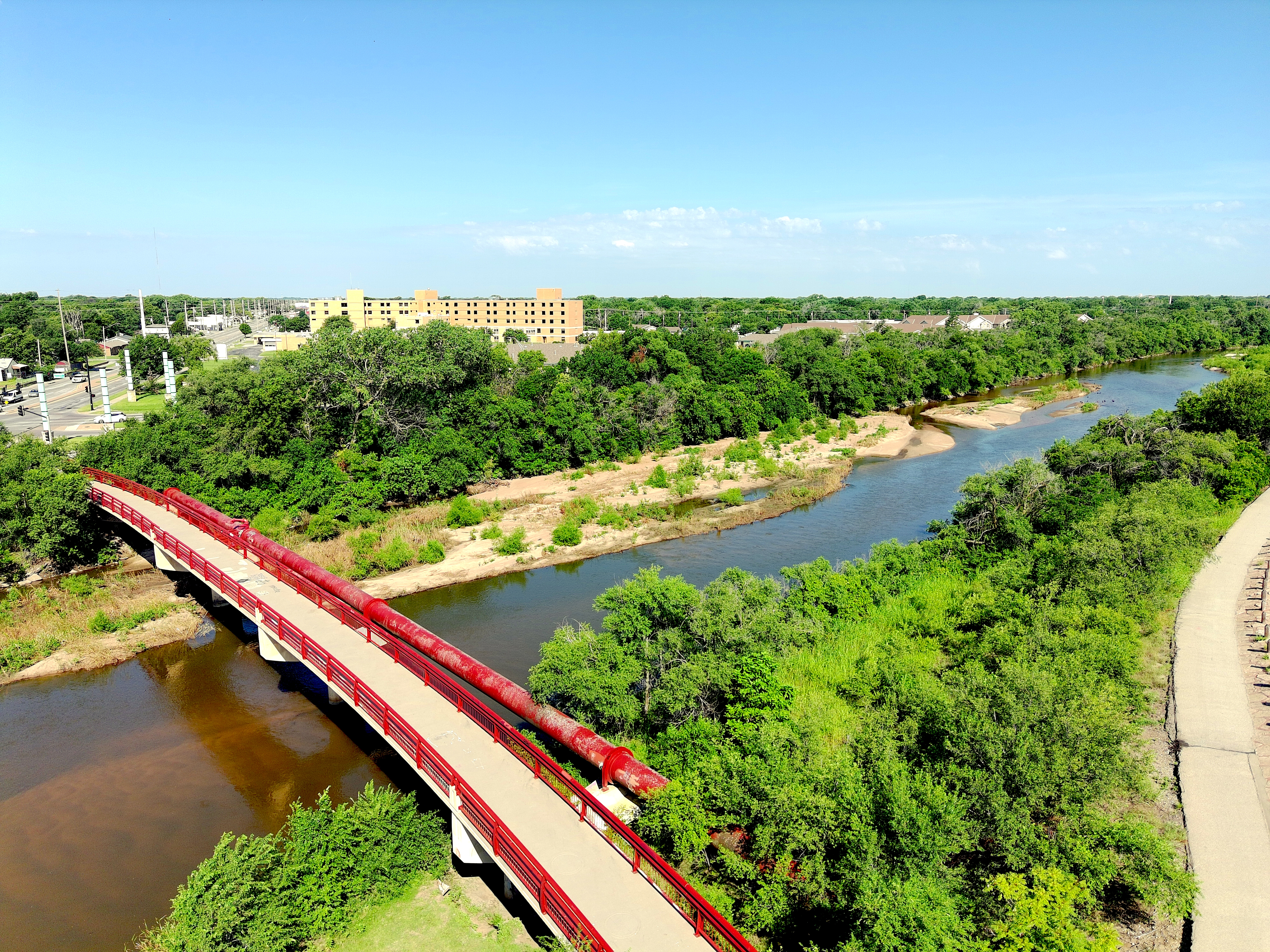
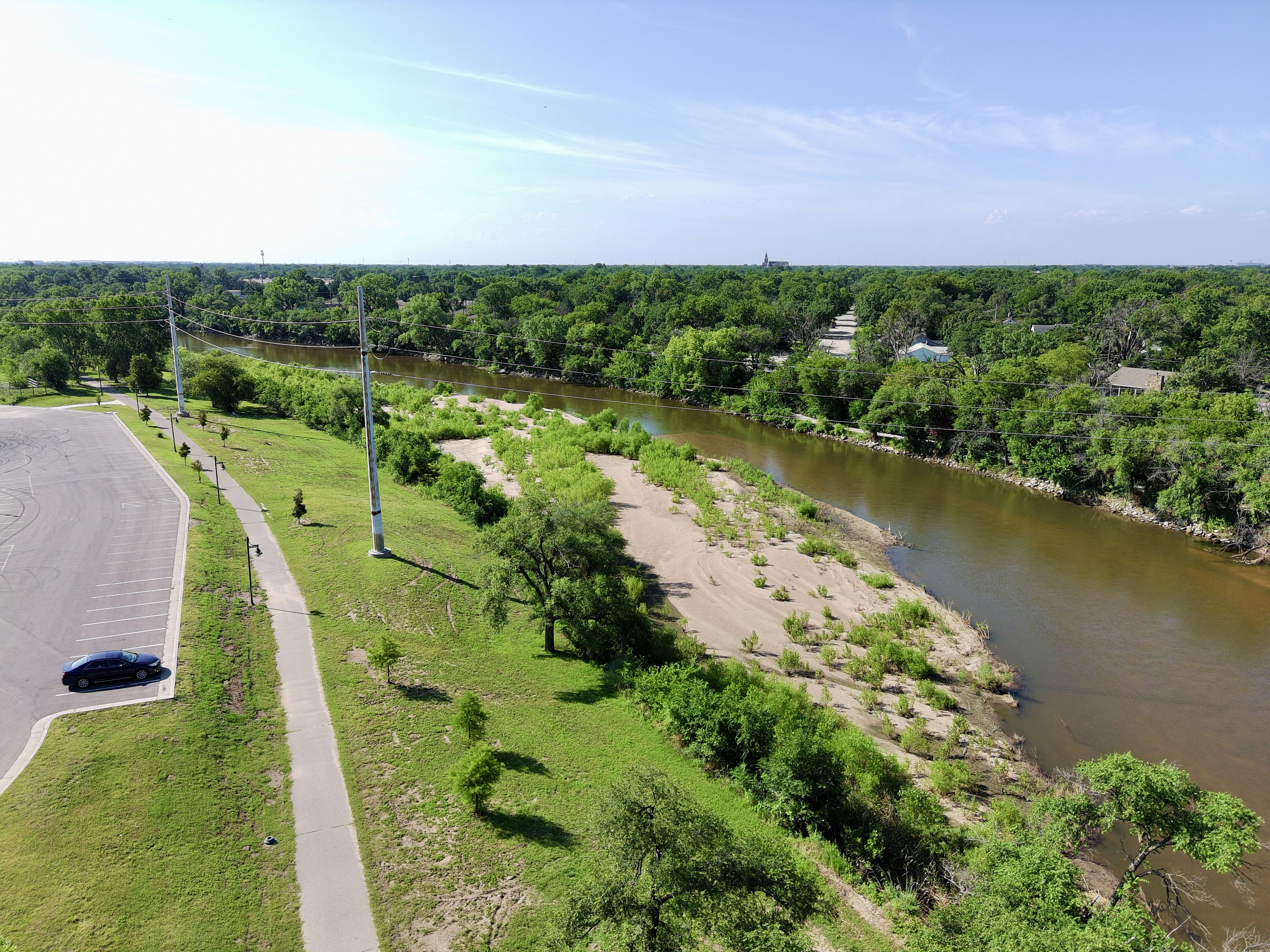
Beautiful spot to fly along the Arkansas River. Usually not too busy, only the occasional biker or pedestrian.
May 28, 2026 2:14 PM
Rules update
• More accurate and detailed rule list.
Place:
McConnell Air Force Base
Changed fields
| Field | Before | After |
|---|---|---|
| Summary | FAA controlled airspace restriction. Review current FAA data and authorization requirements before flying. | FAA controlled airspace restriction, no-fly zone. A-683 special-use airspace for military aircraft. |
Before
## FAA facility airspace restriction


            This area appears in FAA_FS_UAS source data. Drone pilots should verify current FAA requirements, LAANC availability, altitude limits, temporary restrictions, and local conditions before flight.

            This page is based on imported FAA data and may need additional community review.
After
## FAA military facility special-use airspace restriction


Class D controlled airspace. Active military installation. Do not fly here under any circumstances.

            Flying a drone over a military installation is a federal crime under 18 U.S.C. § 1382. Violators face arrest, confiscation of equipment, and federal prosecution. There is no LAANC authorization available for civilian recreational use.
Show inline change markers
+