e798a676-1df0-4134-9a24-76c0fdd27a0a
Showing rules updates and reviews across all places.
Total edits: 128
Reviews: 1
Joined: May 23, 2026
Reputation: 501
Showing 126–129 of 129 activity items.
Page 6 of 6.
Mapped shape change
Old outline is gray. New outline is blue.
May 23, 2026 4:43 PM
Rules update
Place:
Nokaneng
Changed fields
Mapped shape change
Click to load this change into the shared map viewer here.
| Field | Before | After |
|---|---|---|
| Restriction type | Ground | Air |
| Flight status | Unknown | Permission |
| Summary | — | Nokaneng is a small village on the edge of the Okavango Panhandle with limited aviation activity, but occasional low-flying aircraft transiting to and from regional airstrips may be present. Drone operations are generally more feasible than in high-traffic areas, but pilots should remain cautious of unexpected aircraft |
| Mapped shapes | — | 20800ba8-e037-4958-9f06-3526d919c0b5 |
Before
After
Nokaneng – Drone Flying Summary
Summary:
Nokaneng is a small village on the edge of the Okavango Panhandle with limited aviation activity, though occasional low-flying aircraft transiting to and from nearby airstrips may be present.
Drone operations are generally more feasible than in high-traffic areas, but pilots should remain cautious of unexpected aircraft movement and changing wind conditions in open terrain.
The area offers good potential for controlled drone flying, provided operations are conducted away from settlements and with full situational awareness. Always maintain safe altitude limits, keep visual line of sight, and be prepared to land immediately if aircraft are detected.
Risk Level:
Moderate Risk
Best Practice:
Fly away from village and populated areas
Maintain visual line of sight
Stay below 120 m (400 ft) AGL
Monitor for unexpected aircraft
Avoid flying in strong afternoon winds
Notes:
Drone operations in Botswana require approval from the Civil Aviation Authority of Botswana (CAAB)
This is a general safety assessment and not an official controlled airspace designation
Show inline change markers
+ Nokaneng – Drone Flying Summary
+ Summary:
+ Nokaneng is a small village on the edge of the Okavango Panhandle with limited aviation activity, though occasional low-flying aircraft transiting to and from nearby airstrips may be present.
+ Drone operations are generally more feasible than in high-traffic areas, but pilots should remain cautious of unexpected aircraft movement and changing wind conditions in open terrain.
+ The area offers good potential for controlled drone flying, provided operations are conducted away from settlements and with full situational awareness. Always maintain safe altitude limits, keep visual line of sight, and be prepared to land immediately if aircraft are detected.
+ Risk Level:
+ Moderate Risk
+ Best Practice:
+ Fly away from village and populated areas
+ Maintain visual line of sight
+ Stay below 120 m (400 ft) AGL
+ Monitor for unexpected aircraft
+ Avoid flying in strong afternoon winds
+ Notes:
+ Drone operations in Botswana require approval from the Civil Aviation Authority of Botswana (CAAB)
+ This is a general safety assessment and not an official controlled airspace designation
May 23, 2026 4:40 PM
Rules update
Place:
Gumare
Changed fields
Mapped shape change
Click to load this change into the shared map viewer here.
| Field | Before | After |
|---|---|---|
| Restriction type | Ground | Air |
| Flight status | Unknown | Permission |
| Summary | — | Gumare Airport is an active regional airstrip serving light aircraft and charter traffic linked to the Okavango and surrounding areas. Drone operations in the vicinity carry moderate to high aviation risk, particularly due to low-flying aircraft that may approach with little warning. |
| Mapped shapes | — | 9fc820c8-a473-49df-8dfb-688652c55f59 |
Before
After
Gumare Airport Drone Safety Zone (FBGM)
Location:
Center Coordinates: -19.3730, 22.1240
Gumare Airport, Botswana
Recommended No-Fly / Caution Zone
Type: High-risk aviation area (NOT an officially published no-fly zone)
Primary Radius: 5 km from airport center
Extended Approach Zone (recommended due to runway alignment):
East–West: up to 7 km
North–South: up to 4 km
Aircraft typically operate at low altitude in the surrounding area, with approach and departure paths extending beyond the immediate airstrip.
Aviation Risk Factors
Frequent low-flying light aircraft and charter flights
Aircraft may appear suddenly at low altitude
Occasional medical or supply flights without warning
Regional aviation traffic linked to Okavango and Panhandle operations
Drone Pilot Guidance
Avoid flying within 5 km of the airport
Maintain visual line of sight at all times
Do not exceed 120 m (400 ft) AGL
Descend immediately if aircraft are spotted
Avoid flying along likely approach/departure paths
Additional Hazards
Bird activity in surrounding areas may pose a risk to drones
Wind conditions can become unstable, especially in open terrain
Notes
Drone operations in Botswana require approval from the Civil Aviation Authority of Botswana
Additional restrictions may apply in nearby settlements or sensitive areas
This is a safety-based recommended zone, not an official controlled airspace boundary
Show inline change markers
+ Gumare Airport Drone Safety Zone (FBGM)
+ Location:
+ Center Coordinates: -19.3730, 22.1240
+ Gumare Airport, Botswana
+ Recommended No-Fly / Caution Zone
+ Type: High-risk aviation area (NOT an officially published no-fly zone)
+ Primary Radius: 5 km from airport center
+ Extended Approach Zone (recommended due to runway alignment):
+ East–West: up to 7 km
+ North–South: up to 4 km
+ Aircraft typically operate at low altitude in the surrounding area, with approach and departure paths extending beyond the immediate airstrip.
+ Aviation Risk Factors
+ Frequent low-flying light aircraft and charter flights
+ Aircraft may appear suddenly at low altitude
+ Occasional medical or supply flights without warning
+ Regional aviation traffic linked to Okavango and Panhandle operations
+ Drone Pilot Guidance
+ Avoid flying within 5 km of the airport
+ Maintain visual line of sight at all times
+ Do not exceed 120 m (400 ft) AGL
+ Descend immediately if aircraft are spotted
+ Avoid flying along likely approach/departure paths
+ Additional Hazards
+ Bird activity in surrounding areas may pose a risk to drones
+ Wind conditions can become unstable, especially in open terrain
+ Notes
+ Drone operations in Botswana require approval from the Civil Aviation Authority of Botswana
+ Additional restrictions may apply in nearby settlements or sensitive areas
+ This is a safety-based recommended zone, not an official controlled airspace boundary
May 23, 2026 4:35 PM
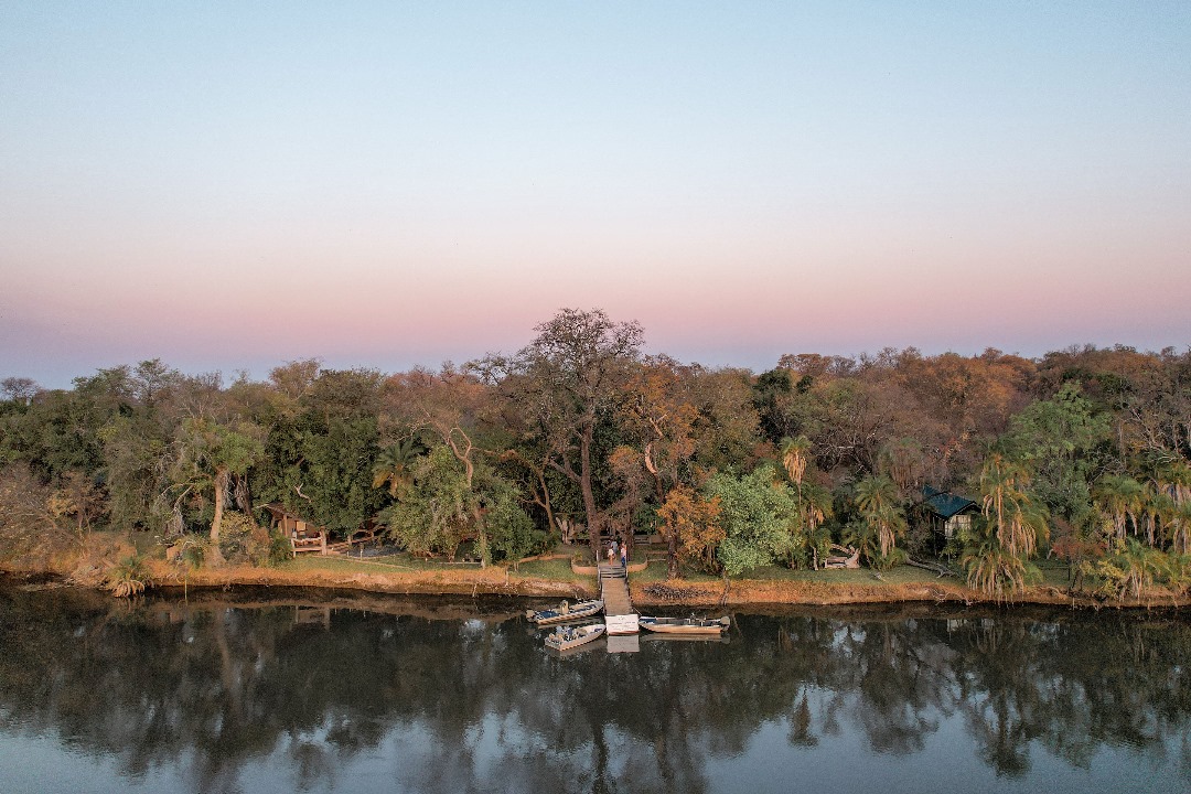
Review
Place:
Xaro Lodge
5 out of 5 stars
5/5
Xaro Lodge is located along the Okavango River near Shakawe, in a relatively open riverine setting outside formal protected park boundaries. Beautiful scenery to capture and amazing mangosteen forest and delta waterways.
Restrictions & Considerations:
Drone use is subject to lodge permission — always confirm before flying
Not within a national park, but still a sensitive tourism environment
Avoid flying over guest areas, boats, or nearby properties
Permission required by Civil aviation authorities to fly in Botswana
May 23, 2026 4:27 PM
Rules update
• Added entire recommendation
Place:
Shakawe
Changed fields
| Field | Before | After |
|---|---|---|
| Restriction type | Ground | Air |
| Flight status | Unknown | Permission |
| Summary | — | High charter aircraft activity associated with Okavango Delta tourism operations. Low-flying aircraft frequently operate in the vicinity of the runway and along river approach corridors. Drone operations within 5 km are strongly discouraged without aviation authority approval and local coordination. |
Before
After
Shakawe Airport Drone Safety Zone (FBSW / SWX)
Location:
Center Coordinates: -18.3739, 21.8326
Shakawe Airport, Botswana
Recommended No-Fly / Caution Zone
Type: High-risk aviation area (NOT an officially published no-fly zone)
Primary Radius: 5 km from airport center
Extended Approach Zone (recommended due to runway alignment 09/27):
East–West: up to 7 km
North–South: up to 4 km
Aircraft primarily approach and depart from the east and west, so extra caution is required along this axis.
Aviation Risk Factors
Frequent low-flying safari charter aircraft
Aircraft may appear suddenly at low altitude
Possible medical evacuation flights without warning
High traffic linked to Okavango Delta tourism operations
Drone Pilot Guidance
Avoid flying within 5 km of the airport
Maintain visual line of sight at all times
Do not exceed 120 m (400 ft) AGL
Descend immediately if aircraft are spotted
Avoid flying along approach/departure paths (east–west axis)
Additional Hazards
Bird activity (especially fish eagles) may attack drones
Afternoon winds can be unpredictable near the river
Notes
Drone operations in Botswana require approval from the Civil Aviation Authority of Botswana (CAAB)
Additional restrictions may apply in nearby wildlife, concession, or lodge areas
This is a safety-based recommended zone, not an official controlled airspace boundary
Show inline change markers
+ Shakawe Airport Drone Safety Zone (FBSW / SWX)
+ Location:
+ Center Coordinates: -18.3739, 21.8326
+ Shakawe Airport, Botswana
+ Recommended No-Fly / Caution Zone
+ Type: High-risk aviation area (NOT an officially published no-fly zone)
+ Primary Radius: 5 km from airport center
+ Extended Approach Zone (recommended due to runway alignment 09/27):
+ East–West: up to 7 km
+ North–South: up to 4 km
+ Aircraft primarily approach and depart from the east and west, so extra caution is required along this axis.
+ Aviation Risk Factors
+ Frequent low-flying safari charter aircraft
+ Aircraft may appear suddenly at low altitude
+ Possible medical evacuation flights without warning
+ High traffic linked to Okavango Delta tourism operations
+ Drone Pilot Guidance
+ Avoid flying within 5 km of the airport
+ Maintain visual line of sight at all times
+ Do not exceed 120 m (400 ft) AGL
+ Descend immediately if aircraft are spotted
+ Avoid flying along approach/departure paths (east–west axis)
+ Additional Hazards
+ Bird activity (especially fish eagles) may attack drones
+ Afternoon winds can be unpredictable near the river
+ Notes
+ Drone operations in Botswana require approval from the Civil Aviation Authority of Botswana (CAAB)
+ Additional restrictions may apply in nearby wildlife, concession, or lodge areas
+ This is a safety-based recommended zone, not an official controlled airspace boundary