3569459f-2e05-4190-ac43-1e693d99c944
Showing rules updates and reviews across all places.
Total edits: 341
Reviews: 39
Joined: Jun 1, 2026
Reputation: 1,001
Showing 301–325 of 380 activity items.
Page 13 of 16.
Mapped shape change
Old outline is gray. New outline is blue.
Jun 3, 2026 2:48 PM
Rules update
• Initial rule details submitted from the map.
Place:
Eckstein bar & food
Changed fields
Mapped shape change
Click to load this change into the shared map viewer here.
Before shape notes
—
After shape notes
- Flying with permission is allowed up to 50m AGL
| Field | Before | After |
|---|---|---|
| Flight status | Unknown | Permission |
| Summary | — | Drone flights at Eckstein bar & food require permission from the managing authority. |
| Mapped shapes | — | ce412b88-dc62-4178-9498-c9f3880c638f |
Before
After
At Eckstein bar & food, the official source says drones require permission from the managing authority inside the mapped boundary. This is because the vbar lies within the airliners starting and landing zones ao you need to get permission and stay below 50m AGL.
Show inline change markers
+ At Eckstein bar & food, the official source says drones require permission from the managing authority inside the mapped boundary. This is because the vbar lies within the airliners starting and landing zones ao you need to get permission and stay below 50m AGL.
Jun 3, 2026 2:47 PM
Rules update
• Initial rule details submitted from the map.
Place:
Hahn Airport
Changed fields
Mapped shape change
Click to load this change into the shared map viewer here.
Before shape notes
—
After shape notes
- No fly zone due to air traffic.
| Field | Before | After |
|---|---|---|
| Flight status | Unknown | NoFly |
| Summary | — | Drone flights at Hahn Airport are prohibited unless the managing authority grants permission. |
| Mapped shapes | — | 45edded5-9308-4a3a-9509-16db0a1fbd46 |
Before
After
At Hahn Airport, the official source says drones are prohibited unless the managing authority grants permission inside the mapped boundary. This is so your drone won't collide with the aircraft wich are departing and landing at the airport.
Show inline change markers
+ At Hahn Airport, the official source says drones are prohibited unless the managing authority grants permission inside the mapped boundary. This is so your drone won't collide with the aircraft wich are departing and landing at the airport.
Jun 3, 2026 2:45 PM
Rules update
• Initial rule details submitted from the map.
Changed fields
Mapped shape change
Click to load this change into the shared map viewer here.
Before shape notes
—
After shape notes
- Flying up to 50m AGL with permission is allowed here
| Field | Before | After |
|---|---|---|
| Flight status | Unknown | Permission |
| Summary | — | Drone flights at Hauptwache Fliegerhorst Büchel require permission from the managing authority. |
| Mapped shapes | — | da45f5db-fda4-487a-a540-a9fd1cd563d0 |
Before
After
At Hauptwache Fliegerhorst Büchel, the official source says drones require permission from the managing authority inside the mapped boundary. This is so that drones do not collide with the low flying planes. Flying is allowed up to 50m AGL with permission.
Show inline change markers
+ At Hauptwache Fliegerhorst Büchel, the official source says drones require permission from the managing authority inside the mapped boundary. This is so that drones do not collide with the low flying planes. Flying is allowed up to 50m AGL with permission.
Jun 3, 2026 2:41 PM
Rules update
• Initial rule details submitted from the map.
Place:
Fliegerhorst Büchel ETSB
Changed fields
Mapped shape change
Click to load this change into the shared map viewer here.
Before shape notes
—
After shape notes
- No fly zone unless you are given special permission
| Field | Before | After |
|---|---|---|
| Flight status | Unknown | NoFly |
| Summary | — | Drone flights at Fliegerhorst Büchel ETSB are prohibited unless the managing authority grants permission. |
| Mapped shapes | — | 4f112dcb-1883-4c46-b23d-6f947cb25e70 |
Before
After
At Fliegerhorst Büchel ETSB, the official source says drones are prohibited unless the managing authority grants permission inside the mapped boundary. This is because it is a commercial airport wich has lots of air traffic and your drone could collide with the airliners.
Show inline change markers
+ At Fliegerhorst Büchel ETSB, the official source says drones are prohibited unless the managing authority grants permission inside the mapped boundary. This is because it is a commercial airport wich has lots of air traffic and your drone could collide with the airliners.
Jun 3, 2026 2:37 PM
Rules update
• Initial rule details submitted from the map.
Changed fields
Mapped shape change
Click to load this change into the shared map viewer here.
Before shape notes
—
After shape notes
- Flying allowed up to 50m AGL with permission
| Field | Before | After |
|---|---|---|
| Flight status | Unknown | Permission |
| Summary | — | Drone flights at Bundeswehr Feuerwehr Holzdorf require permission from the managing authority. |
| Mapped shapes | — | cd27b8d1-e443-431a-a2c1-38521d183c58 |
Before
After
At Bundeswehr Feuerwehr Holzdorf, the official source says drones require permission from the managing authority inside the mapped boundary. You are allowed to fly up to 50m AGL if you have p[ermission from the government.
Show inline change markers
+ At Bundeswehr Feuerwehr Holzdorf, the official source says drones require permission from the managing authority inside the mapped boundary. You are allowed to fly up to 50m AGL if you have p[ermission from the government.
Jun 3, 2026 2:35 PM
Rules update
• Initial rule details submitted from the map.
Place:
Fliegerhorst Holzdorf ETSH
Changed fields
Mapped shape change
Click to load this change into the shared map viewer here.
Before shape notes
—
After shape notes
- No fly zone unless special permission is granted.
| Field | Before | After |
|---|---|---|
| Flight status | Unknown | NoFly |
| Summary | — | Drone flights at Fliegerhorst Holzdorf ETSH are prohibited unless the managing authority grants permission. |
| Mapped shapes | — | 661f6a1a-e4cd-449a-b733-93fe47e50dbb |
Before
After
At Fliegerhorst Holzdorf ETSH, the official source says drones are prohibited unless the managing authority grants permission inside the mapped boundary. This is because this is a military airport wich is illegal; to fly nearby.
Show inline change markers
+ At Fliegerhorst Holzdorf ETSH, the official source says drones are prohibited unless the managing authority grants permission inside the mapped boundary. This is because this is a military airport wich is illegal; to fly nearby.
Jun 2, 2026 7:02 PM
Rules update
• Initial rule details submitted from the map.
Changed fields
Mapped shape change
Click to load this change into the shared map viewer here.
Before shape notes
—
After shape notes
- Flying with permission up to 50m AGL
| Field | Before | After |
|---|---|---|
| Flight status | Unknown | Permission |
| Summary | — | Drone flights at Eifel Arms Inns Temporary Lodging require permission from the managing authority. |
| Mapped shapes | — | 4a98bae5-92c3-4926-b208-7e4d1d58f191 |
Before
After
At Eifel Arms Inns Temporary Lodging, the official source says drones require permission from the managing authority inside the mapped boundary. This is because it lies within the proximity of spangdahlem air base where you can only fly up to 50m AGL with permission.
Show inline change markers
+ At Eifel Arms Inns Temporary Lodging, the official source says drones require permission from the managing authority inside the mapped boundary. This is because it lies within the proximity of spangdahlem air base where you can only fly up to 50m AGL with permission.
Jun 2, 2026 7:00 PM
Rules update
• Initial rule details submitted from the map.
Place:
Spangdahlem Air Base - ETAD
Changed fields
Mapped shape change
Click to load this change into the shared map viewer here.
| Field | Before | After |
|---|---|---|
| Flight status | Unknown | NoFly |
| Summary | — | Drone flights at Spangdahlem Air Base - ETAD are prohibited unless the managing authority grants permission. |
| Mapped shapes | — | 424e866b-ad6a-47fa-84c2-eaa473ed93cc |
Before
After
At Spangdahlem Air Base - ETAD, the official source says drones are prohibited unless the managing authority grants permission inside the mapped boundary. This is because it is a military airbase and flying within its proximity is illegal.
Show inline change markers
+ At Spangdahlem Air Base - ETAD, the official source says drones are prohibited unless the managing authority grants permission inside the mapped boundary. This is because it is a military airbase and flying within its proximity is illegal.
Jun 2, 2026 6:57 PM
Rules update
• Initial rule details submitted from the map.
Place:
FineTime TakeOff Bar
Changed fields
Mapped shape change
Click to load this change into the shared map viewer here.
Before shape notes
—
After shape notes
- Flying with permission up to 50m AGL
| Field | Before | After |
|---|---|---|
| Flight status | Unknown | Permission |
| Summary | — | Drone flights at FineTime TakeOff Bar require permission from the managing authority. |
| Mapped shapes | — | f6d2f26e-3d2b-4af9-b7aa-a981b1c00a11 |
Before
After
At FineTime TakeOff Bar, the official source says drones require permission from the managing authority inside the mapped boundary. this is due to the bar being located inside of the zone around the airport nearby where you can only fly up to 50m AGL with permission.
Show inline change markers
+ At FineTime TakeOff Bar, the official source says drones require permission from the managing authority inside the mapped boundary. this is due to the bar being located inside of the zone around the airport nearby where you can only fly up to 50m AGL with permission.
Jun 2, 2026 6:54 PM
Rules update
• Initial rule details submitted from the map.
Place:
Flughafen Saarbrücken
Changed fields
Mapped shape change
Click to load this change into the shared map viewer here.
Before shape notes
—
After shape notes
- Here is a no fly zone unless given special permission
| Field | Before | After |
|---|---|---|
| Flight status | Unknown | NoFly |
| Summary | — | Drone flights at Flughafen Saarbrücken are prohibited unless the managing authority grants permission. |
| Mapped shapes | — | 96dda1d4-401a-4a0e-9d90-06c1b123ed6a |
Before
After
At Flughafen Saarbrücken, the official source says drones are prohibited unless the managing authority grants permission inside the mapped boundary. This is to prevent crashes between airliners and drones.
Show inline change markers
+ At Flughafen Saarbrücken, the official source says drones are prohibited unless the managing authority grants permission inside the mapped boundary. This is to prevent crashes between airliners and drones.
Jun 2, 2026 6:51 PM
Rules update
• Initial rule details submitted from the map.
Place:
Ramstein Main Exchange
Changed fields
Mapped shape change
Click to load this change into the shared map viewer here.
Before shape notes
—
After shape notes
- Flying with permission up to 50m AGL
| Field | Before | After |
|---|---|---|
| Flight status | Unknown | Permission |
| Summary | — | Drone flights at Ramstein Main Exchange require permission from the government. |
| Mapped shapes | — | 9971897c-5f7e-4387-9126-e0ecc85aeff7 |
Before
After
At Ramstein Main Exchange, the official source states, that drones require permission to be flown inside of this zone with a maximum altitude of 50m AGL. this permission needs to be given out by the government.
Show inline change markers
+ At Ramstein Main Exchange, the official source states, that drones require permission to be flown inside of this zone with a maximum altitude of 50m AGL. this permission needs to be given out by the government.
Jun 2, 2026 6:48 PM
Rules update
• Initial rule details submitted from the map.
Changed fields
Mapped shape change
Click to load this change into the shared map viewer here.
| Field | Before | After |
|---|---|---|
| Flight status | Unknown | NoFly |
| Summary | — | Drone Flights at Amerikanische Luftwaffenbasis Ramstein are prohibited unless the government grants you permission. |
| Mapped shapes | — | 4a4fe89f-01c6-416f-be20-ff376b91663b |
Before
After
At Amerikanische Luftwaffenbasis Ramstein, the official source says drones are prohibited unless the managing authority grants permission inside the mapped boundary. this is due to military air traffic being frequent in this area.
Show inline change markers
+ At Amerikanische Luftwaffenbasis Ramstein, the official source says drones are prohibited unless the managing authority grants permission inside the mapped boundary. this is due to military air traffic being frequent in this area.
Jun 2, 2026 5:39 PM
Rules update
• Updated The rule explanation and added a link to back up the data
Changed fields
Mapped shape change
Click to load this change into the shared map viewer here.
Before shape notes
—
After shape notes
- No fly zone 5km at the ends of the runway and 1km to the sides
| Field | Before | After |
|---|---|---|
| Restriction type | Ground | Air |
| Flight status | Unknown | NoFly |
| Summary | — | Drone flights at Flughafen Karlsruhe/Baden-baden are illegal and prohibited unless you get special permission from the government. |
| Mapped shapes | — | 492fb8ae-82dc-4f54-87d8-025c94eb002c |
Before
After
At Flughafen Karlsruhe/Baden-Baden, the official source says drones are prohibited unless the managing authority grants permission inside the mapped boundary. this is so drones won't collide with airliners.
Show inline change markers
+ At Flughafen Karlsruhe/Baden-Baden, the official source says drones are prohibited unless the managing authority grants permission inside the mapped boundary. this is so drones won't collide with airliners.
Jun 2, 2026 5:35 PM
Rules update
• Initial rule details submitted from the map.
Place:
DHL Frachtzentrum Lahr
Changed fields
Mapped shape change
Click to load this change into the shared map viewer here.
Before shape notes
—
After shape notes
- Fly up to 50m AGL with permission.
| Field | Before | After |
|---|---|---|
| Flight status | Unknown | Permission |
| Summary | — | Drone flights near DHL Frachtzentrum Lahr require permission from the government. |
| Mapped shapes | — | 21a3b164-cdc8-4061-a0d7-e6b7ac98b5cb |
Before
After
At DHL Frachtzentrum Lahr, the official source says drones require permission from the managing authority inside the mapped boundary. this is due to low flying airliners.
Show inline change markers
+ At DHL Frachtzentrum Lahr, the official source says drones require permission from the managing authority inside the mapped boundary. this is due to low flying airliners.
Jun 2, 2026 5:33 PM
Rules update
• Initial rule details submitted from the map.
Place:
Flughafen Lahr EDTL
Changed fields
Mapped shape change
Click to load this change into the shared map viewer here.
Before shape notes
—
After shape notes
- No fly zone due to air traffic
| Field | Before | After |
|---|---|---|
| Flight status | Unknown | NoFly |
| Summary | — | Drone flights at Flughafen Lahr EDTL are prohibited unless the government grants you permission. |
| Mapped shapes | — | a66cd64d-8ab6-426a-85f1-6f1690fff0e0 |
Before
After
At Flughafen Lahr EDTL, the official source says drones are prohibited unless the managing authority grants permission inside the mapped boundary. this is because there is frequent air traffic at this airport.
Show inline change markers
+ At Flughafen Lahr EDTL, the official source says drones are prohibited unless the managing authority grants permission inside the mapped boundary. this is because there is frequent air traffic at this airport.
Jun 2, 2026 5:24 PM
Rules update
• Initial rule details submitted from the map.
Place:
Parkland-Klinik
Changed fields
Mapped shape change
Click to load this change into the shared map viewer here.
Before shape notes
—
After shape notes
- 1.5 km range where permission is required to fly.
| Field | Before | After |
|---|---|---|
| Flight status | Unknown | Permission |
| Summary | — | You need to stay 1.5 km. away from the hospitals helipad. |
| Mapped shapes | — | a5f52ce3-9149-43fa-90c9-bd44f10be4a2 |
Before
After
This hospital has a helipad wich means that it has frequent air traffic from low flying helicopters wich need be avoided in order to not cause a collision.
Show inline change markers
+ This hospital has a helipad wich means that it has frequent air traffic from low flying helicopters wich need be avoided in order to not cause a collision.
Jun 2, 2026 5:20 PM
Rules update
• Initial rule details submitted from the map.
Place:
POCO Erfurt
Changed fields
Mapped shape change
Click to load this change into the shared map viewer here.
Before shape notes
—
After shape notes
- permission required zone fly up to 50m AGL
| Field | Before | After |
|---|---|---|
| Flight status | Unknown | Permission |
| Summary | — | You need permission to fly here up to 50m AGL due to it being near the airport Erfurt-weimar wich has very frequent air traffic. |
| Mapped shapes | — | 38232c11-c3ef-49f2-b547-e0a386d395ee |
Before
After
This is a zone around the German airport Erfurt-Weimar and you need permission in order to fly here, because there are low flying aircraft in the area that could collide with your drone.
Show inline change markers
+ This is a zone around the German airport Erfurt-Weimar and you need permission in order to fly here, because there are low flying aircraft in the area that could collide with your drone.
Jun 2, 2026 5:13 PM
Rules update
• Initial rule details submitted from the map.
Changed fields
Mapped shape change
Click to load this change into the shared map viewer here.
Before shape notes
—
After shape notes
- Fly with permission up to 50m AGL
| Field | Before | After |
|---|---|---|
| Flight status | Unknown | Permission |
| Summary | — | You need permission to fly here up to 50m AGL |
| Mapped shapes | — | e73e4e91-5164-4ba3-a8db-d33b4c9f9538 |
Before
After
This is the area around the airport Dresden in Germany and you need permission to fly here, because there are planes flying in this area and if you have permission you are allowed to fly under 50mAGL
Show inline change markers
+ This is the area around the airport Dresden in Germany and you need permission to fly here, because there are planes flying in this area and if you have permission you are allowed to fly under 50mAGL
Jun 2, 2026 5:09 PM
Rules update
• Initial rule details submitted from the map.
Place:
Helipad Bundeswehr Fritzlar
Changed fields
Mapped shape change
Click to load this change into the shared map viewer here.
Before shape notes
—
After shape notes
- can fly up to 50m AGL with permiossion
| Field | Before | After |
|---|---|---|
| Flight status | Unknown | Permission |
| Summary | — | Here you are allowed to fly up to 50 m high with permission |
| Mapped shapes | — | 8ed592fc-51dc-4563-8e91-1f7d0d9313a7 |
Before
After
In this area you can request permission in order to fly up to 50m AGL high. this is because this is a Military airport wich is nearby so you need permission to fly near it, otherwise you are committing a crime.
Show inline change markers
+ In this area you can request permission in order to fly up to 50m AGL high. this is because this is a Military airport wich is nearby so you need permission to fly near it, otherwise you are committing a crime.
Jun 2, 2026 5:05 PM
Rules update
• Initial rule details submitted from the map.
Place:
Bundeswehrflugplatz Fritzlar
Changed fields
Mapped shape change
Click to load this change into the shared map viewer here.
| Field | Before | After |
|---|---|---|
| Flight status | Unknown | NoFly |
| Summary | — | This is a German Military airbase flying here is absolutely illegal and not allowed. |
| Mapped shapes | — | 9e8a0f66-0d0d-4e47-a6b9-73bb053c9525 |
Before
After
Due to this being a military airport of the German military flying here is highly illegal and you need to stay at least 5km away from the ends of the runways and 1km from the sides.
Show inline change markers
+ Due to this being a military airport of the German military flying here is highly illegal and you need to stay at least 5km away from the ends of the runways and 1km from the sides.
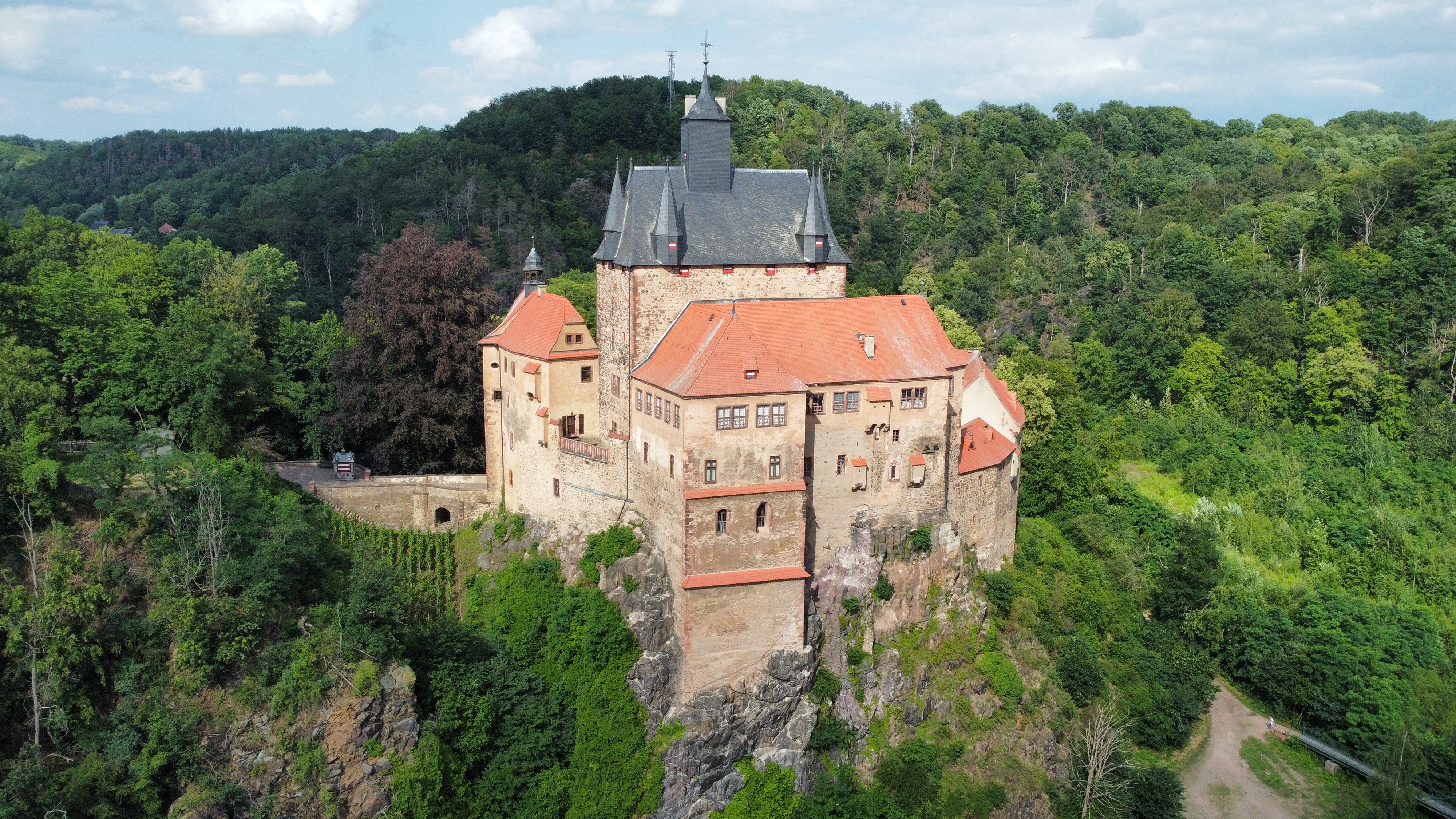
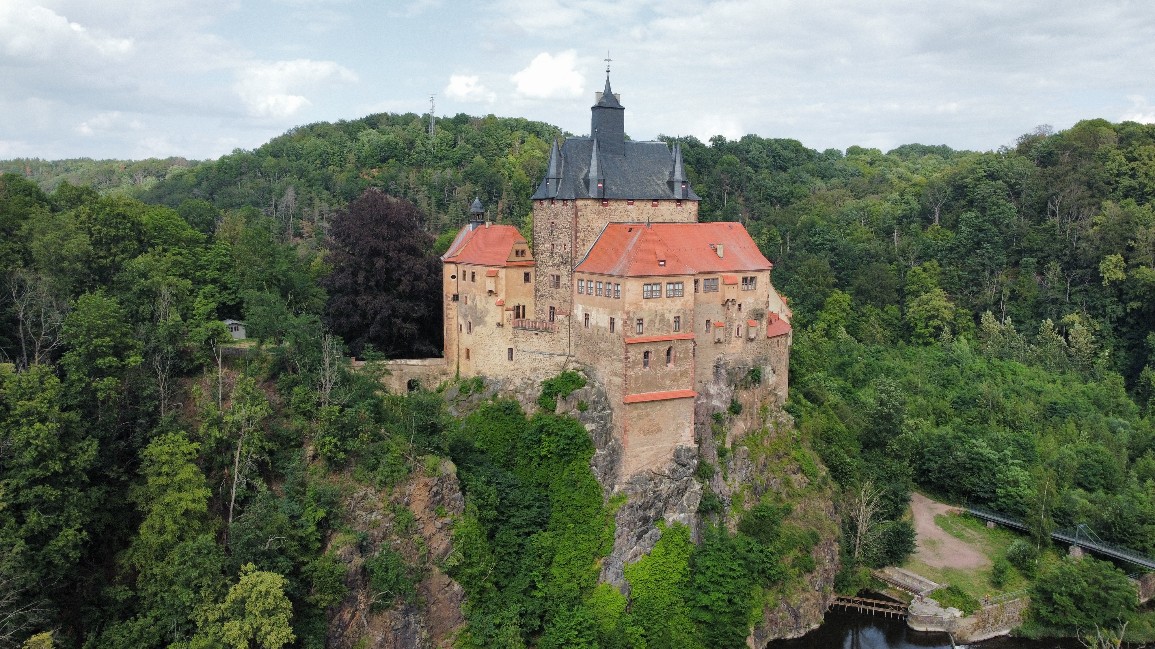
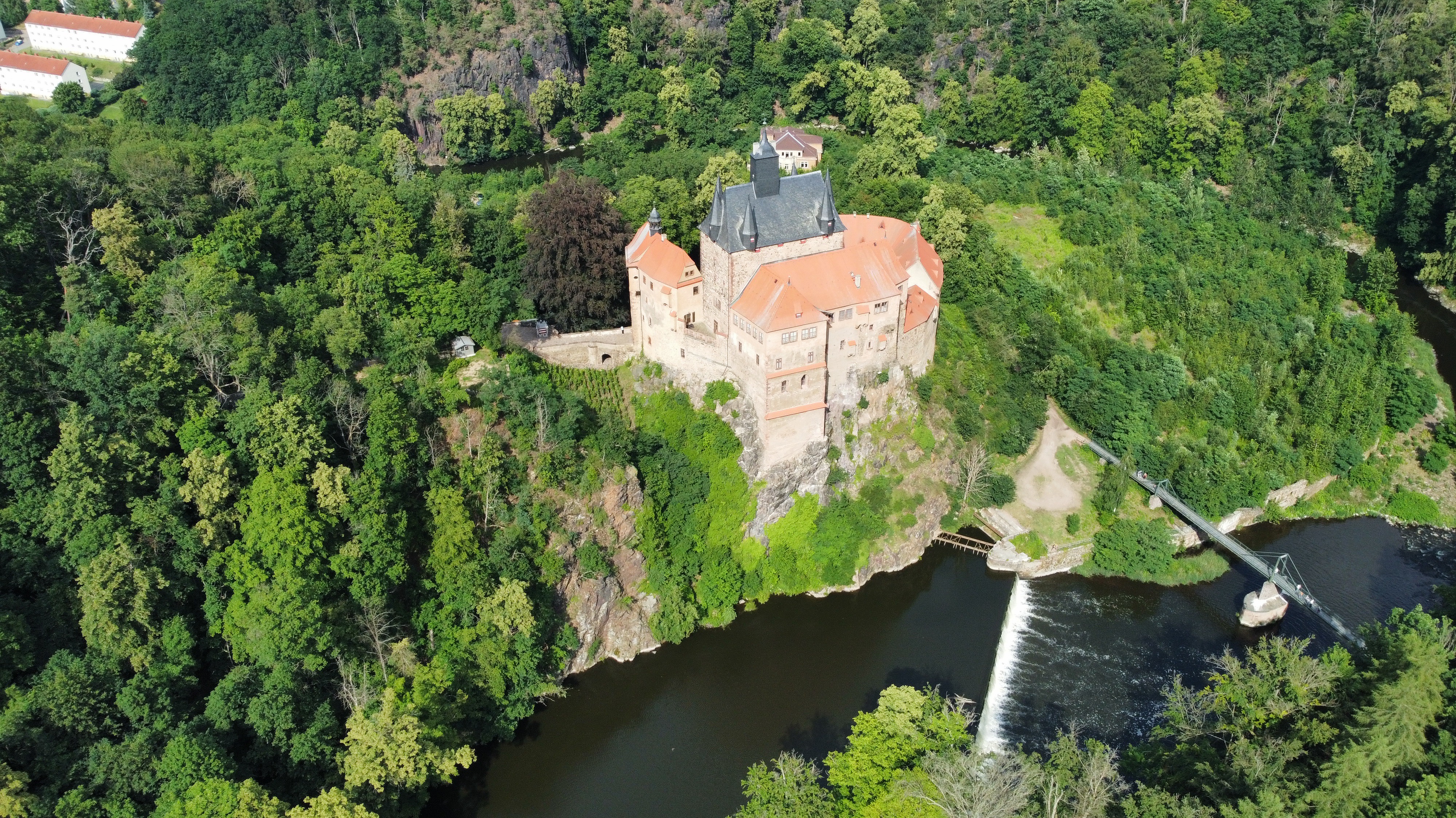
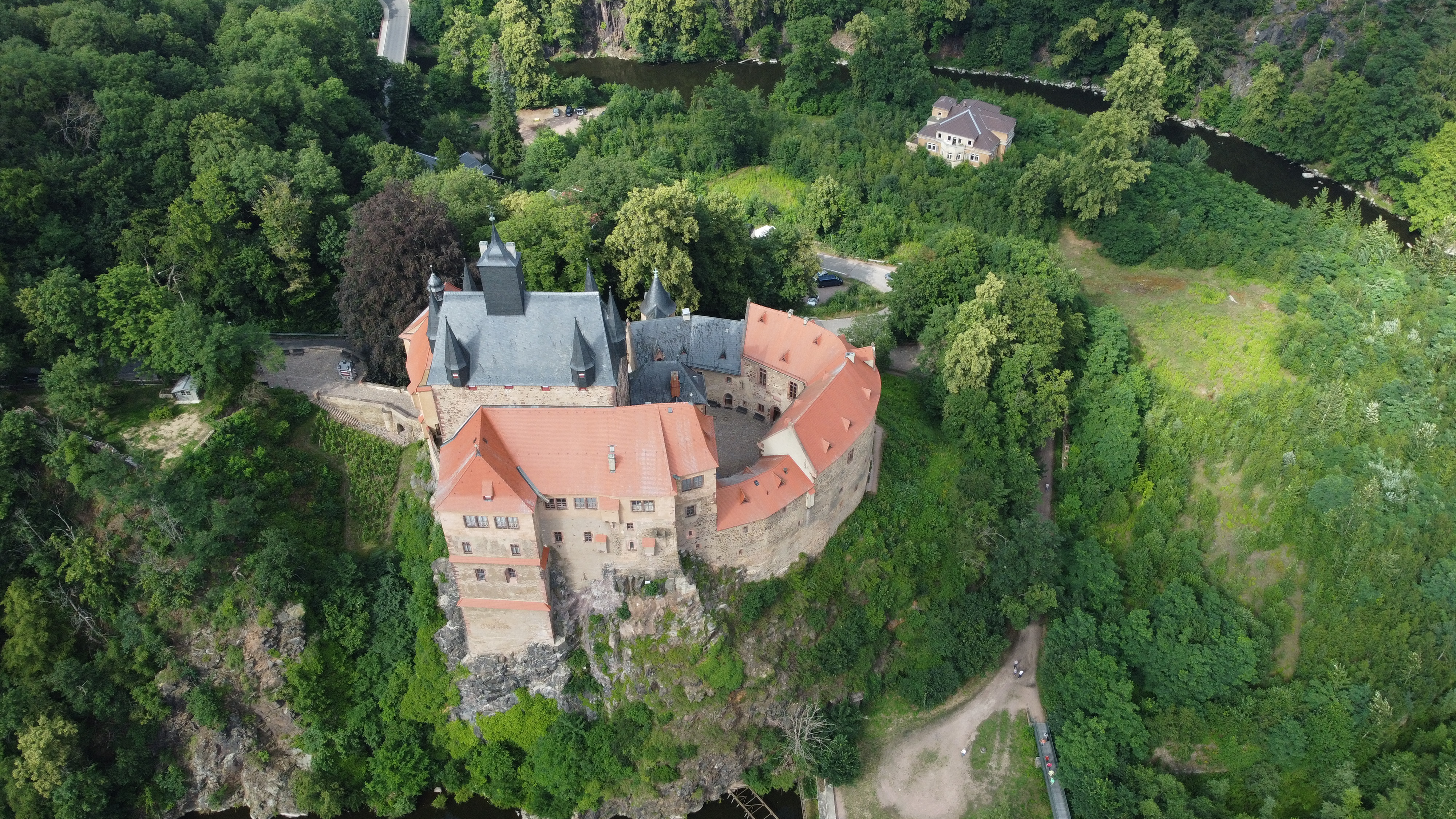
Jun 2, 2026 5:00 PM
Review
Place:
Burg Kriebstein
5 out of 5 stars
5/5
pretty nice German castle with a surrounding river. you need to be careful to not fly into the castle.
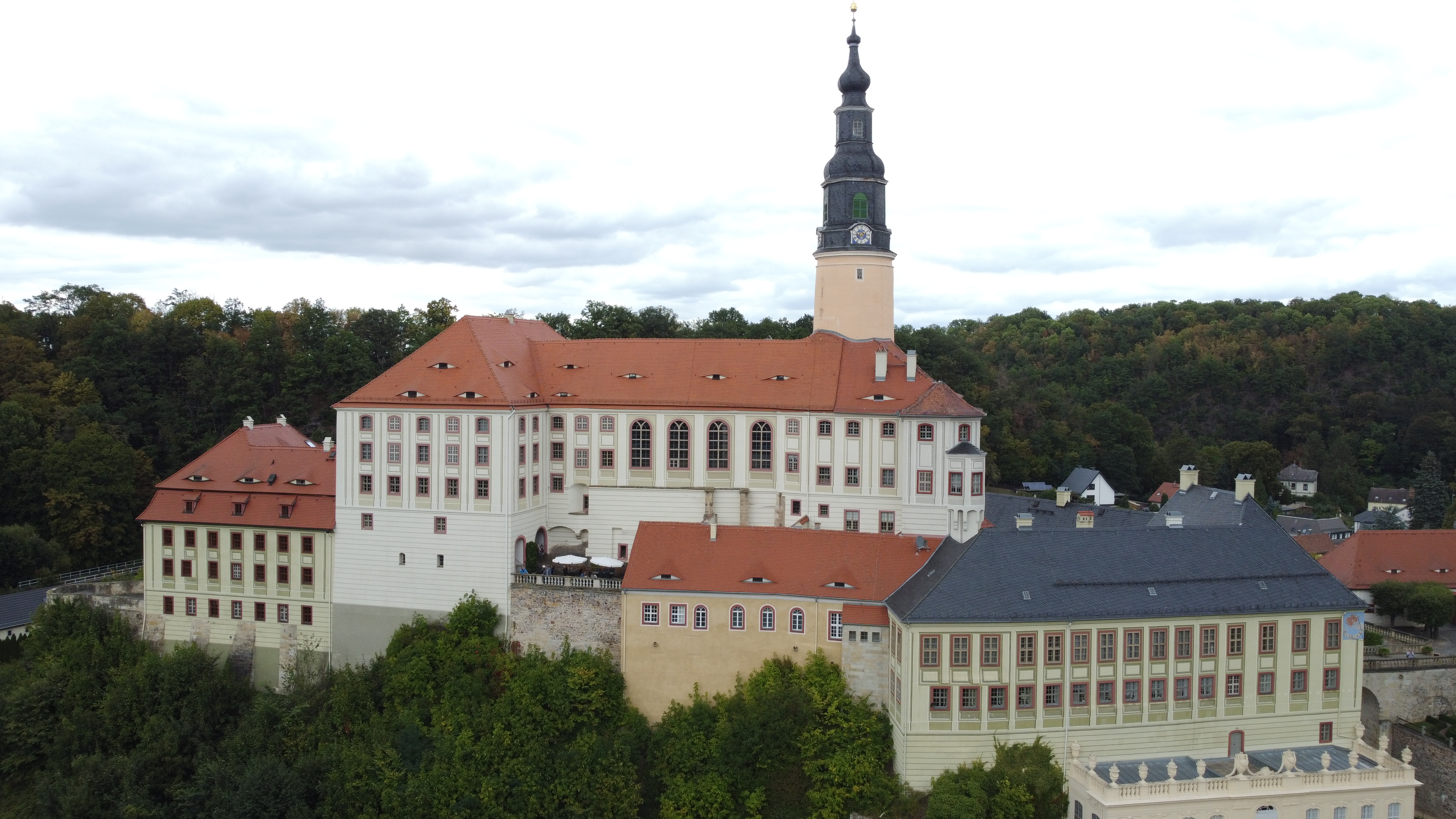
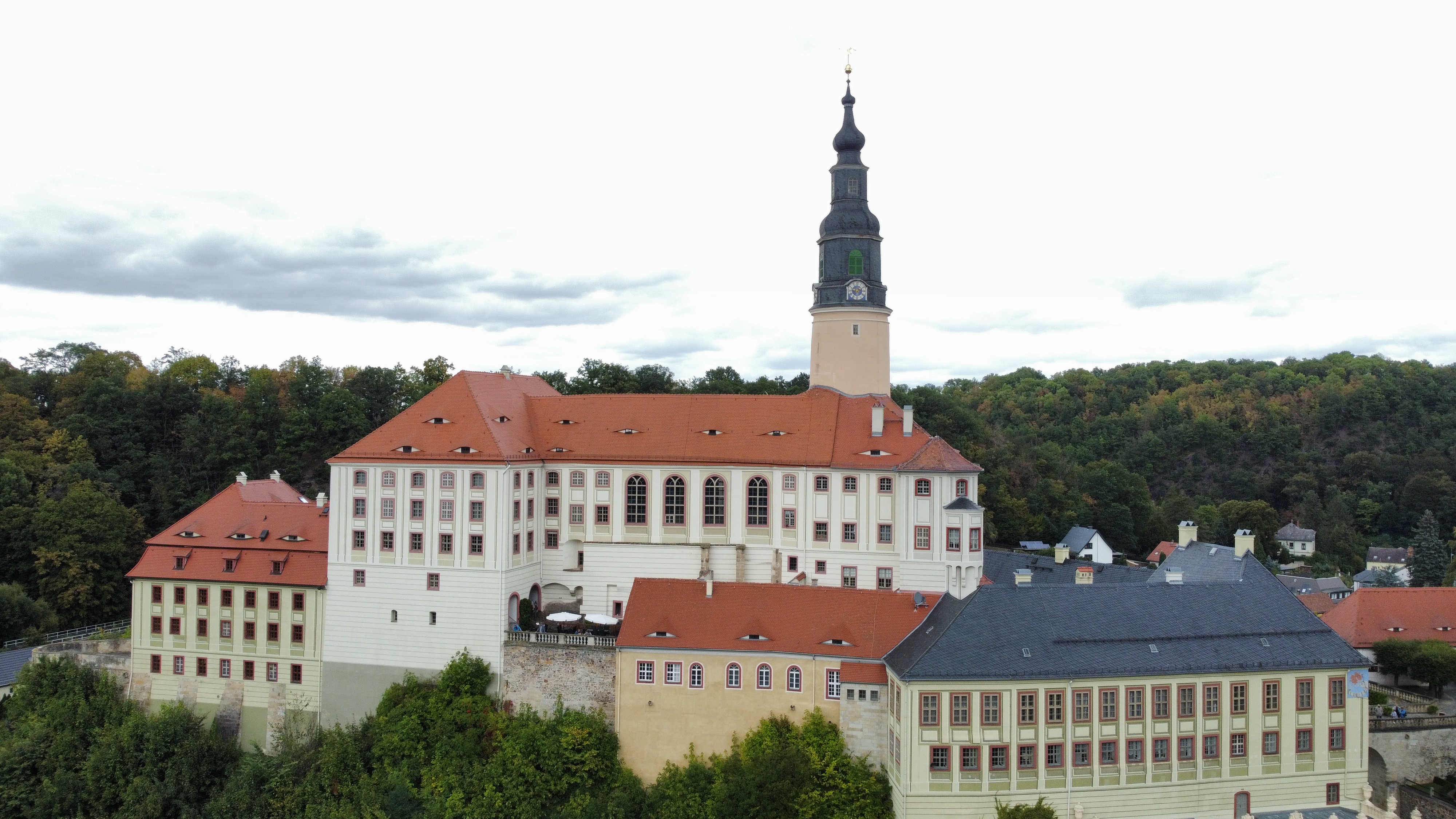
Jun 2, 2026 4:56 PM
Review
Place:
Schloss Weesenstein
5 out of 5 stars
5/5
nice and old German castle wich is surrounded by trees so you have to be careful flying here
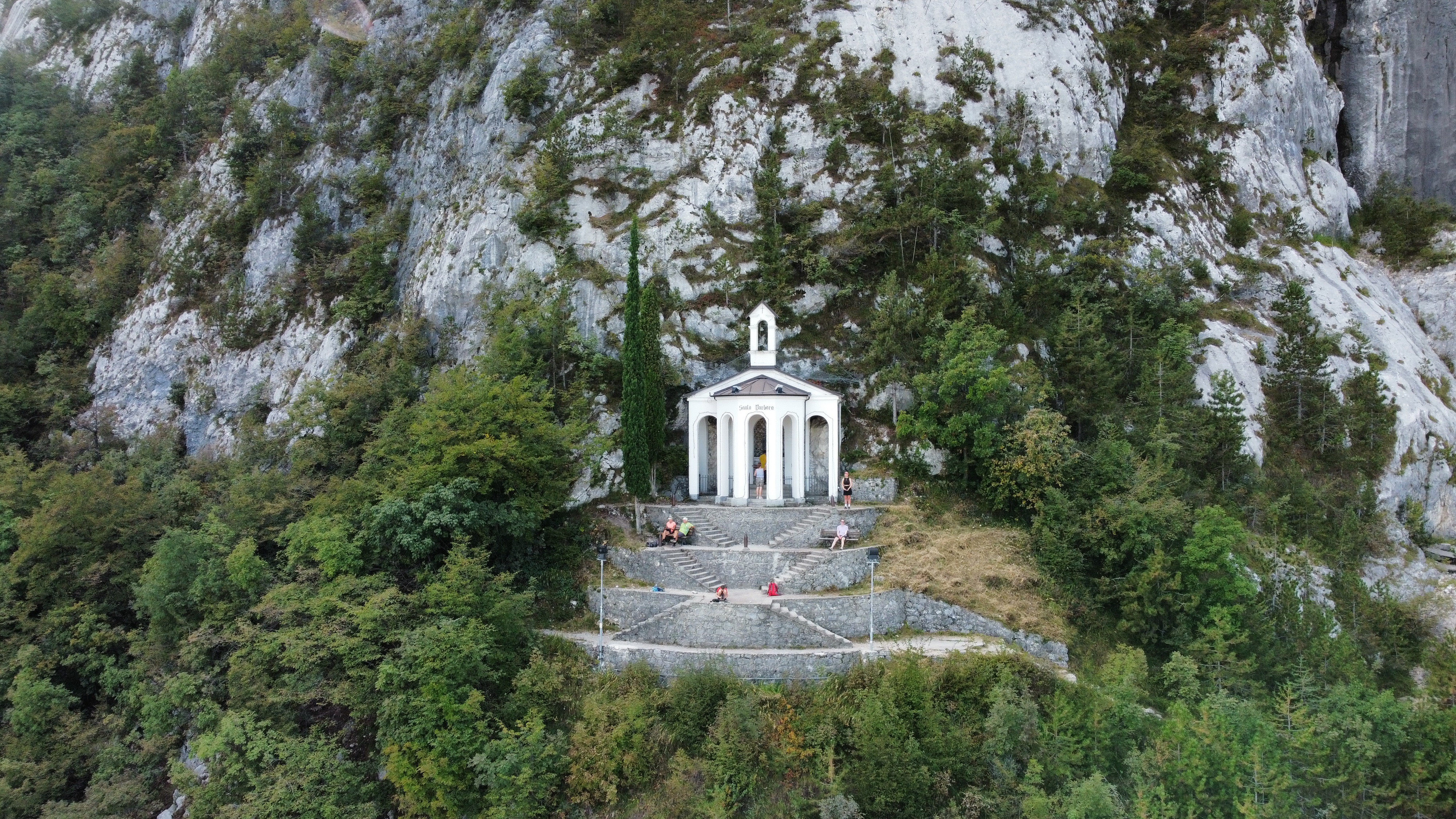
Jun 2, 2026 4:54 PM
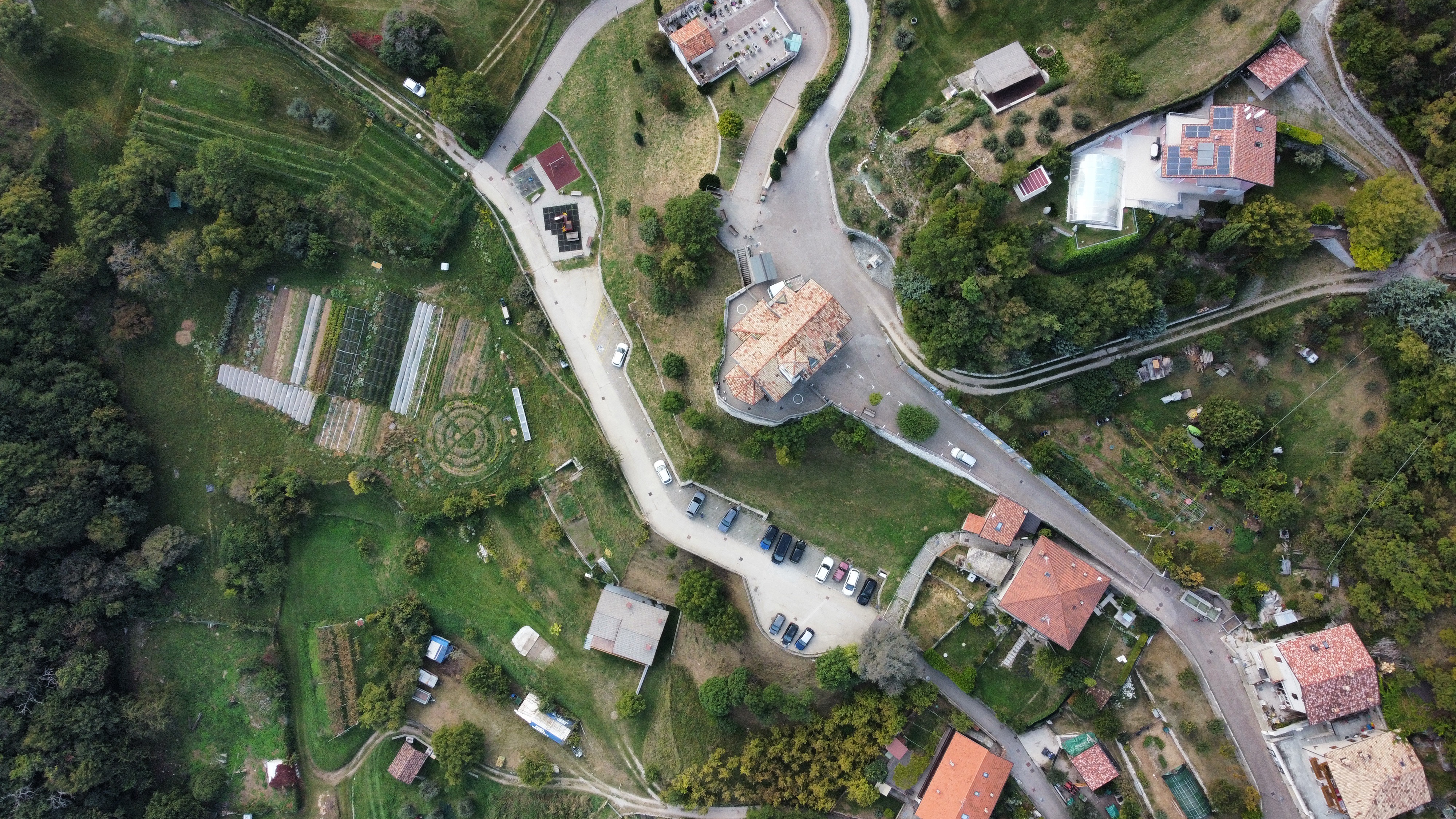
Review
Place:
Cascata del Ponale
5 out of 5 stars
5/5
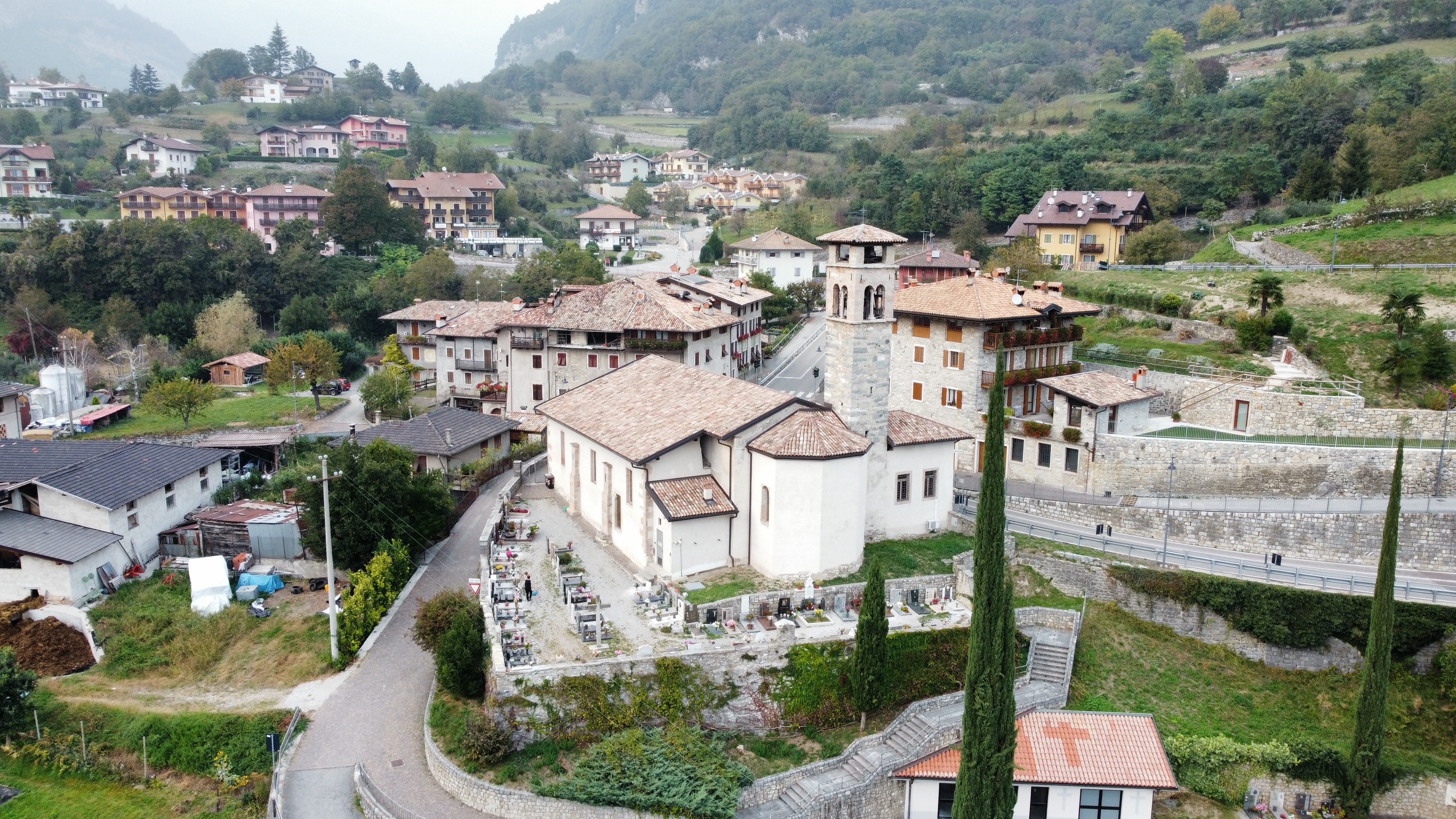
very small church wich its located on top of a hill. its a very long hike to get there but the view is worth it.
Jun 2, 2026 4:53 PM
Review
Place:
La Piazzetta di Canale R&B
5 out of 5 stars
5/5
Here you can fly freely and take in the nice views swell as the background noises from the animals wich are very relaxing.
Jun 2, 2026 4:49 PM
Review
5 out of 5 stars
5/5
nice castle located near the Lago di Garda in Italy with nice views of the lake and nice animal noises in the background